
Mancos topographic map
Interactive map
Click on the map to display elevation.
About this map
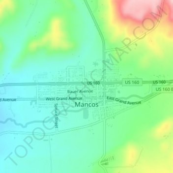
Name: Mancos topographic map, elevation, terrain.
Location: Mancos, Montezuma County, Colorado, United States (37.34148 -108.30495 37.35229 -108.28236)
Average elevation: 7,080 ft
Minimum elevation: 6,903 ft
Maximum elevation: 7,493 ft
According to the United States Census Bureau, Mancos has a total area of 0.6 square miles (1.6 km2), all of it recorded as land. The town is located in the Mancos River valley at an elevation of approximately 7,000 feet (2,100 m). The Mancos River was named by Spanish explorers (Rio de los Mancos - "River of the Sleeve") perhaps for the way the river, which rises in the La Plata Mountains northeast of Mancos, drains the valley and then flows into the narrow confines of Weber Canyon and Mancos Canyon, southwest of Mesa Verde, where it joins the San Juan River. The town's skyline is dominated by the mass of Mesa Verde 7 miles (11 km) to the west, Menefee Mountain 2 miles (3 km) to the southeast, and the La Plata Mountains, a range to the east and northeast, in which the headwaters of the Mancos River originate.
Other topographic maps
Click on a map to view its topography, its elevation and its terrain.
Millwood
United States > Colorado > Montezuma County
Millwood, Montezuma County, Colorado, United States
Average elevation: 7,612 ft
Mesa Verde National Park
United States > Colorado > Montezuma County
Mesa Verde National Park, Montezuma County, Colorado, 81330, United States
Average elevation: 7,044 ft
Cortez
United States > Colorado > Montezuma County
Cortez, Montezuma County, Colorado, 81321, United States
Average elevation: 6,119 ft
Chimney Rock
United States > Colorado > Montezuma County
Chimney Rock, Montezuma County, Colorado, United States
Average elevation: 5,381 ft
Menefee Peak
United States > Colorado > Montezuma County
Menefee Peak, Montezuma County, Colorado, United States
Average elevation: 8,192 ft
Mancos
United States > Colorado > Montezuma County > Mancos
Mancos, Montezuma County, Colorado, 81328-9151, United States
Average elevation: 7,241 ft
Cortez
United States > Colorado > Montezuma County > Cortez
Cortez, Montezuma County, Colorado, 81321-3299, United States
Average elevation: 6,132 ft
Towaoc
United States > Colorado > Montezuma County > Towaoc
Towaoc, Montezuma County, Colorado, United States
Average elevation: 5,935 ft
Hesperus Mountain
United States > Colorado > Montezuma County
Hesperus Mountain, Montezuma County, Colorado, United States
Average elevation: 11,752 ft