
Make a donation
Gear up for your next adventure:
As an Amazon Associate, this site earns from qualifying purchases at no extra cost to you.
Cape Breton Island topographic map
Click on the map to display elevation.
Make a donation
Gear up for your next adventure:
As an Amazon Associate, this site earns from qualifying purchases at no extra cost to you.
Cape Breton Island
The island is characterized by a number of elevations of ancient crystalline and metamorphic rock rising up from the south to the north, and contrasted with eroded lowlands. The bedrock of blocks that developed in different places around the globe, at different times, and then were fused together via tectonics.
Make a donation
Gear up for your next adventure:
As an Amazon Associate, this site earns from qualifying purchases at no extra cost to you.
About this map
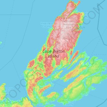
Name: Cape Breton Island topographic map, elevation, terrain.
Location: Cape Breton Island, Nova Scotia, Canada (45.54803 -61.55268 47.04205 -59.78811)
Average elevation: 217 ft
Minimum elevation: -10 ft
Maximum elevation: 1,742 ft
Make a donation
Gear up for your next adventure:
As an Amazon Associate, this site earns from qualifying purchases at no extra cost to you.
Other topographic maps
Click on a map to view its topography, its elevation and its terrain.
Princton Heights Park
Canada > Nova Scotia > Municipality of Colchester > Salmon River
Average elevation: 194 ft
Make a donation
Gear up for your next adventure:
As an Amazon Associate, this site earns from qualifying purchases at no extra cost to you.
Margaret Boone Memorial Park
Canada > Nova Scotia > Cape Breton Regional Municipality > Dominion
Average elevation: 43 ft
Centreville
Canada > Nova Scotia > Cape Breton Regional Municipality > Sydney Mines
Average elevation: 39 ft
Make a donation
Gear up for your next adventure:
As an Amazon Associate, this site earns from qualifying purchases at no extra cost to you.
Their Light Shall Always Shine Memorial Park
Canada > Nova Scotia > Municipality of Pictou County > Priestville
Average elevation: 105 ft
Flat Rock
Canada > Nova Scotia > Municipality of the County of Richmond > Grand River
Average elevation: 16 ft
Make a donation
Gear up for your next adventure:
As an Amazon Associate, this site earns from qualifying purchases at no extra cost to you.
Sutherlands Lake
Canada > Nova Scotia > Guysborough County > Lower Caledonia
Average elevation: 476 ft
Make a donation
Gear up for your next adventure:
As an Amazon Associate, this site earns from qualifying purchases at no extra cost to you.
Lumsden Pond
Canada > Nova Scotia > Municipality of the County of Kings > Lumsden Dam
Average elevation: 558 ft
Make a donation
Gear up for your next adventure:
As an Amazon Associate, this site earns from qualifying purchases at no extra cost to you.
Western Island
Canada > Nova Scotia > Guysborough District Municipality > Cole Harbour
Average elevation: 85 ft
Make a donation
Gear up for your next adventure:
As an Amazon Associate, this site earns from qualifying purchases at no extra cost to you.
Valley Station
Canada > Nova Scotia > Municipality of Colchester > Valley Station
Average elevation: 197 ft
Make a donation
Gear up for your next adventure:
As an Amazon Associate, this site earns from qualifying purchases at no extra cost to you.
McClures Mills
Canada > Nova Scotia > Colchester County > Truro > McClures Mills
Average elevation: 151 ft
Make a donation
Gear up for your next adventure:
As an Amazon Associate, this site earns from qualifying purchases at no extra cost to you.
Jakes Landing
Canada > Nova Scotia > Municipality of the County of Annapolis > Kejimkujik National Park of Canada
Average elevation: 335 ft
Make a donation
Gear up for your next adventure:
As an Amazon Associate, this site earns from qualifying purchases at no extra cost to you.