
Hampstead Heath topographic map
Interactive map
Click on the map to display elevation.
About this map
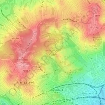
Name: Hampstead Heath topographic map, elevation, terrain.
Average elevation: 308 ft
Minimum elevation: 115 ft
Maximum elevation: 446 ft
Other topographic maps
Click on a map to view its topography, its elevation and its terrain.
Romford
United Kingdom > England > London
The town centre is about 50 feet (15 m) above sea level on a gravel terrace rising from the River Thames. The north of the town has developed on London Clay and is situated as much as 150 ft (46 m) above sea level. A continuous gentle rise in the eastern suburbs towards Gidea Park and Harold Wood peaks around…
Average elevation: 95 ft
London Borough of Bromley
United Kingdom > England > London
Westerham Heights, the highest point in London and Kent at an altitude of 804 feet (245 m), is on the southern boundary. The Prime Meridian passes through Bromley.
Average elevation: 341 ft