
Maury County topographic map
Click on the map to display elevation.
About this map
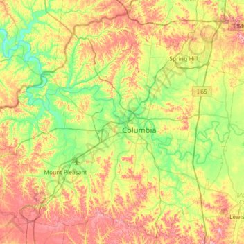
Name: Maury County topographic map, elevation, terrain.
Location: Maury County, Middle Tennessee, Tennessee, United States (35.40871 -87.35430 35.85050 -86.78202)
Average elevation: 771 ft
Minimum elevation: 479 ft
Maximum elevation: 1,214 ft
Tennessee trails, hiking, mountain biking, running and outdoor activities
Other topographic maps
Click on a map to view its topography, its elevation and its terrain.
Mount Le Conte
United States > Tennessee > Sevier County
Mount Le Conte (or LeConte) is a mountain located within the Great Smoky Mountains National Park in Sevier County, Tennessee. At 6,593 ft (2,010 m) it is the third highest peak in the national park, behind Kuwohi (formerly Clingmans Dome) (6,643 ft (2,025 m)) and Mount Guyot (6,621 ft (2,018 m)). It is also…
Average elevation: 5,449 ft
Roan Mountain State Park
United States > Tennessee > Carter County > Roan Mountain
Roan Mountain State Park hosts a variety of outdoor activities including hiking, mountain biking, camping, cross-country skiing (during snowy, winter months), fishing, and swimming. A heated swimming pool is open from Memorial Day to mid-August. At an elevation of 2,972 feet (906 m), the outdoor swimming pool…
Average elevation: 3,241 ft
Henderson Springs
United States > Tennessee > Sevier County > Pigeon Forge
Average elevation: 1,079 ft
Eastdale
United States > Tennessee > Hamilton County > Chattanooga > Ridgeside
Average elevation: 778 ft
Ridgedale
United States > Tennessee > Hamilton County > Chattanooga > Ridgeside
Average elevation: 768 ft
Barfield Crescent Park
United States > Tennessee > Rutherford County > Murfreesboro
Average elevation: 659 ft
Stonehenge Estates
United States > Tennessee > Williamson County > Brentwood
Average elevation: 840 ft
Cherokee Dam - Saddle Dam No. 1
United States > Tennessee > Jefferson County
Average elevation: 1,053 ft
Brainerd
United States > Tennessee > Hamilton County > Chattanooga > Ridgeside
Average elevation: 768 ft
Millersville City Park
United States > Tennessee > Robertson County > Millersville
Average elevation: 853 ft
Grassland Addition
United States > Tennessee > Cumberland County > Crossville
Average elevation: 1,837 ft