
Make a donation
Gear up for your next adventure:
As an Amazon Associate, this site earns from qualifying purchases at no extra cost to you.
Erie County topographic map
Click on the map to display elevation.
Make a donation
Gear up for your next adventure:
As an Amazon Associate, this site earns from qualifying purchases at no extra cost to you.
Erie County
The northern border of the county is Tonawanda Creek. Part of the southern border is Cattaraugus Creek. Other major streams include Buffalo Creek (Buffalo River), Cayuga Creek, Cazenovia Creek, Scajaquada Creek, Eighteen Mile Creek and Ellicott Creek. The county's northern half, including Buffalo and its suburbs, is known as the Northtowns and is relatively flat and rises gently up from the lake. The southern half, known as the Southtowns, is much hillier. It has the northwesternmost foothills of the Appalachian Mountains. The highest elevation in the county is a hill in the Town of Sardinia that tops out at around 1,940 feet (591 m) above sea level. The lowest ground is about 560 feet (171 m), on Grand Island at the Niagara River. The Onondaga Escarpment runs through the northern part of Erie County.
Make a donation
Gear up for your next adventure:
As an Amazon Associate, this site earns from qualifying purchases at no extra cost to you.
About this map
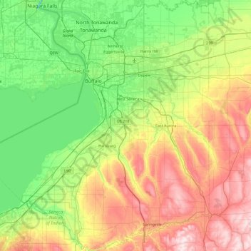
Name: Erie County topographic map, elevation, terrain.
Location: Erie County, New York, United States (42.43800 -79.29797 43.09870 -78.46174)
Average elevation: 938 ft
Minimum elevation: 325 ft
Maximum elevation: 2,129 ft
New York trails, hiking, mountain biking, running and outdoor activities
Make a donation
Gear up for your next adventure:
As an Amazon Associate, this site earns from qualifying purchases at no extra cost to you.
Other topographic maps
Click on a map to view its topography, its elevation and its terrain.
Central Park
United States > New York > New York County > New York
In June 1856, Fernando Wood appointed a "consulting board" of seven people, headed by author Washington Irving, to inspire public confidence in the proposed development. Wood hired military engineer Egbert Ludovicus Viele as the park's chief engineer, tasking him with a topographical survey of the site. The…
Average elevation: 85 ft
Make a donation
Gear up for your next adventure:
As an Amazon Associate, this site earns from qualifying purchases at no extra cost to you.
Millers Pond
United States > New York > Suffolk County > Town of Smithtown > Village of the Branch
Average elevation: 66 ft
Make a donation
Gear up for your next adventure:
As an Amazon Associate, this site earns from qualifying purchases at no extra cost to you.
Bucks Bridge
United States > New York > Saint Lawrence County > Town of Potsdam
Average elevation: 322 ft
Tug Hill
United States > New York > Oswego County
The core Tug Hill region encompasses 150,000 acres (610 km2) of unbroken, generally second-growth, northern hardwood forest, and is drained by a vast network of streams. Important rivers and streams whose headwaters are located within the Tug Hill region include the Mohawk River, Deer River, Salmon River, Mad…
Average elevation: 358 ft
Hoopers Valley Island
United States > New York > Tioga County > Hoopers Valley
Average elevation: 876 ft
Make a donation
Gear up for your next adventure:
As an Amazon Associate, this site earns from qualifying purchases at no extra cost to you.
North Germantown
United States > New York > Columbia County > Town of Germantown
Average elevation: 112 ft
Big Bad Luck Pond
United States > New York > Hamilton County > Town of Indian Lake
Average elevation: 1,768 ft
Make a donation
Gear up for your next adventure:
As an Amazon Associate, this site earns from qualifying purchases at no extra cost to you.
Mount Marcy
United States > New York > Essex County > Town of Keene
Mount Marcy is the highest point in the Adirondack Mountains and the U.S. state of New York, with an elevation of 5,343.1 feet (1,628.6 m). It is located in the town of Keene in Essex County. The mountain is in the heart of the High Peaks Wilderness Area in Adirondack Park. Like the surrounding Adirondack…
Average elevation: 4,229 ft
Ellicottville
United States > New York > Cattaraugus County > Village of Ellicottville
Average elevation: 1,880 ft
Make a donation
Gear up for your next adventure:
As an Amazon Associate, this site earns from qualifying purchases at no extra cost to you.
North Fair Haven
United States > New York > Cayuga County > Town of Sterling
Average elevation: 269 ft
Kane's Falls
United States > New York > Washington County > Town of Fort Ann
Average elevation: 194 ft
Make a donation
Gear up for your next adventure:
As an Amazon Associate, this site earns from qualifying purchases at no extra cost to you.
Tusten Mountain Lake
United States > New York > Sullivan County > Town of Tusten
Average elevation: 1,135 ft
Mount Tremper
United States > New York > Ulster County > Town of Shandaken
Average elevation: 1,125 ft
Make a donation
Gear up for your next adventure:
As an Amazon Associate, this site earns from qualifying purchases at no extra cost to you.
Hartfield
United States > New York > Chautauqua County > Town of Chautauqua
Average elevation: 1,404 ft
Make a donation
Gear up for your next adventure:
As an Amazon Associate, this site earns from qualifying purchases at no extra cost to you.
Chenango Lake
United States > New York > Chenango County > Town of New Berlin
Average elevation: 1,683 ft
Make a donation
Gear up for your next adventure:
As an Amazon Associate, this site earns from qualifying purchases at no extra cost to you.
Lake Lincolndale
United States > New York > Westchester County > Town of Somers > Shenorock
Average elevation: 531 ft
Make a donation
Gear up for your next adventure:
As an Amazon Associate, this site earns from qualifying purchases at no extra cost to you.
Cedar Knolls
United States > New York > Westchester County > City of Yonkers
Average elevation: 187 ft
Make a donation
Gear up for your next adventure:
As an Amazon Associate, this site earns from qualifying purchases at no extra cost to you.
New Britain
United States > New York > Columbia County > Town of New Lebanon
Average elevation: 1,020 ft
Make a donation
Gear up for your next adventure:
As an Amazon Associate, this site earns from qualifying purchases at no extra cost to you.
Make a donation
Gear up for your next adventure:
As an Amazon Associate, this site earns from qualifying purchases at no extra cost to you.
East Poestenkill
United States > New York > Rensselaer County > Town of Poestenkill
Average elevation: 1,234 ft
Make a donation
Gear up for your next adventure:
As an Amazon Associate, this site earns from qualifying purchases at no extra cost to you.
Make a donation
Gear up for your next adventure:
As an Amazon Associate, this site earns from qualifying purchases at no extra cost to you.
Beaver Dam Lake
United States > New York > Orange County > Town of New Windsor
Average elevation: 387 ft
Make a donation
Gear up for your next adventure:
As an Amazon Associate, this site earns from qualifying purchases at no extra cost to you.
Handsome Pond
United States > New York > Hamilton County > Town of Long Lake
Average elevation: 1,926 ft
Hawthorne
United States > New York > Westchester County > Town of Mount Pleasant
Average elevation: 390 ft
Make a donation
Gear up for your next adventure:
As an Amazon Associate, this site earns from qualifying purchases at no extra cost to you.
Make a donation
Gear up for your next adventure:
As an Amazon Associate, this site earns from qualifying purchases at no extra cost to you.
Make a donation
Gear up for your next adventure:
As an Amazon Associate, this site earns from qualifying purchases at no extra cost to you.
Reynolds
United States > New York > Rensselaer County > Town of Schaghticoke
Average elevation: 144 ft
Roberto Clemente State Park
United States > New York > Bronx County > New York
Average elevation: 105 ft
Make a donation
Gear up for your next adventure:
As an Amazon Associate, this site earns from qualifying purchases at no extra cost to you.
Upper Lansingburg Reservoir Dam
United States > New York > Rensselaer County > City of Troy
Average elevation: 302 ft
Make a donation
Gear up for your next adventure:
As an Amazon Associate, this site earns from qualifying purchases at no extra cost to you.
Cedar Knolls
United States > New York > Westchester County > City of Yonkers
Average elevation: 187 ft
Make a donation
Gear up for your next adventure:
As an Amazon Associate, this site earns from qualifying purchases at no extra cost to you.
Catskills Visitor Center
United States > New York > Ulster County > Town of Shandaken > Beechford
Average elevation: 988 ft
Make a donation
Gear up for your next adventure:
As an Amazon Associate, this site earns from qualifying purchases at no extra cost to you.
Benjamin's Memorial Beach
United States > New York > Suffolk County > Bay Shore
Average elevation: 7 ft
Make a donation
Gear up for your next adventure:
As an Amazon Associate, this site earns from qualifying purchases at no extra cost to you.
Fisherman's Landing
United States > New York > Erie County > Town of Grand Island > Grandyle Village
Average elevation: 587 ft
Barberville
United States > New York > Rensselaer County > Town of Poestenkill
Average elevation: 883 ft
Chestnut Ridge Park
United States > New York > Erie County > Town of Orchard Park
Average elevation: 1,030 ft
Make a donation
Gear up for your next adventure:
As an Amazon Associate, this site earns from qualifying purchases at no extra cost to you.