Geolocate

Forestville topographic map

Interactive map

Click on the map to display elevation.

About this map

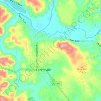
Name: Forestville topographic map, elevation, terrain.

Location: Forestville, Sonoma County, California, United States (38.46338 -122.92021 38.50421 -122.85160)

Average elevation: 187 ft

Minimum elevation: 26 ft

Maximum elevation: 502 ft

Sonoma County trails, hiking, mountain biking, running and outdoor activities

Other topographic maps

Click on a map to view its topography, its elevation and its terrain.

Russian River

United States > California > Sonoma County > Guerneville > El Bonita

The geographer R. S. Holway wrote of the Russian River in his 1917 paper "The Russian River: A Characteristic Stream of the California Coast Ranges". Originally, the Russian River was one of several rivers draining westward from the Mayacamas Mountains through the Mendocino Plateau to the sea, a region lifted…

Average elevation: 591 ft

Sears Point

United States > California > Sonoma County

Average elevation: 52 ft

Geyserville

United States > California > Sonoma County

Average elevation: 338 ft

Simi

United States > California > Sonoma County > Healdsburg

Average elevation: 223 ft

Rio Nido

United States > California > Sonoma County > Guerneville

Average elevation: 381 ft

Sonoma Mountain

United States > California > Sonoma County

Sonoma Mountain is a prominent landform within the Sonoma Mountains of southern Sonoma County, California. At an elevation of 2,463 ft (751 m), Sonoma Mountain offers expansive views of the Pacific Ocean to the west and the Sonoma Valley to the east. In fact, the viticultural area extends in isolated patches…

Average elevation: 1,946 ft

Rio Dell

United States > California > Sonoma County

Average elevation: 243 ft

Cazadero

United States > California > Sonoma County

Average elevation: 568 ft

Fitch Mountain

United States > California > Sonoma County

Average elevation: 259 ft

Melita

United States > California > Sonoma County > Santa Rosa

Average elevation: 486 ft

Petaluma

United States > California > Sonoma County > Petaluma

Average elevation: 384 ft

Roseland

United States > California > Sonoma County > Santa Rosa

Average elevation: 135 ft

Sea Ranch

United States > California > Sonoma County

Average elevation: 187 ft

Guernewood

United States > California > Sonoma County

Average elevation: 377 ft

Northwood

United States > California > Sonoma County

Average elevation: 377 ft

Annapolis

United States > California > Sonoma County

Average elevation: 659 ft

Sebastopol

United States > California > Sonoma County

Sebastopol's elevation is 65 to 250 feet (20 to 76 meters) above sea level. Its downtown is at the intersection of State Route 12 and State Route 116 (Gravenstein Highway), approximately 9 mi (14 km) west of U.S. Route 101.

Average elevation: 141 ft

Monte Rosa

United States > California > Sonoma County

Average elevation: 509 ft

Edendale

United States > California > Sonoma County > Edendale

Average elevation: 295 ft

Sebastopol

United States > California > Sonoma County > Sebastopol > Sebastopol

Sebastopol's elevation is 65 to 250 feet (20 to 76 meters) above sea level. Its downtown is at the intersection of State Route 12 and State Route 116 (Gravenstein Highway), approximately 9 mi (14 km) west of U.S. Route 101.

Average elevation: 135 ft

Bodega Bay

United States > California > Sonoma County

Average elevation: 194 ft

Santa Rosa

United States > California > Sonoma County > Santa Rosa

Average elevation: 538 ft

Bonilla

United States > California > Sonoma County > Bonilla

Average elevation: 98 ft

Jenner

United States > California > Sonoma County

Average elevation: 292 ft

Cotati

United States > California > Sonoma County

Average elevation: 138 ft

Chianti

United States > California > Sonoma County

Average elevation: 394 ft

Lakeville

United States > California > Sonoma County > Lakeville

Average elevation: 92 ft