
Worthing topographic map
Interactive map
Click on the map to display elevation.
About this map
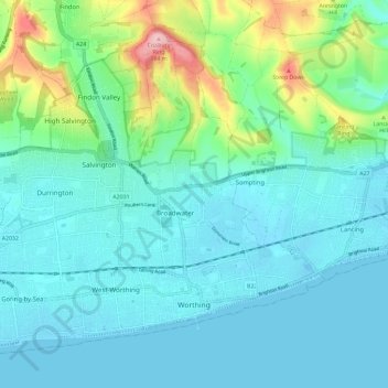
Name: Worthing topographic map, elevation, terrain.
Location: Worthing, West Sussex, England, United Kingdom (50.80174 -0.44656 50.86326 -0.33026)
Average elevation: 115 ft
Minimum elevation: -10 ft
Maximum elevation: 600 ft
Other topographic maps
Click on a map to view its topography, its elevation and its terrain.
Blackdown
United Kingdom > England > West Sussex > Chichester
Blackdown, or Black Down, summit elevation 279.7 metres (918 ft) AMSL, is the highest point in both the historic county of Sussex and the South Downs National Park. It is one of the highest points in the south east of England, exceeded by Walbury Hill, Leith Hill and Pilot Hill. Blackdown is protected as part…
Average elevation: 541 ft
Donnington Park
United Kingdom > England > West Sussex > Chichester > Apuldram
Average elevation: 26 ft
Adsdean Down
United Kingdom > England > West Sussex > Chichester > Stoughton
Average elevation: 285 ft
Washington Common
United Kingdom > England > West Sussex > Storrington > Washington
Average elevation: 200 ft
Worth Abbey
United Kingdom > England > West Sussex > Mid Sussex > Turners Hill
Average elevation: 407 ft
Gay Street
United Kingdom > England > West Sussex > Horsham > West Chiltington
Average elevation: 125 ft
Wick
United Kingdom > England > West Sussex > Arun > Littlehampton > Lyminster
Average elevation: 10 ft
Sullington Warren
United Kingdom > England > West Sussex > Horsham > Storrington
Average elevation: 177 ft
Henry Burt Wood
United Kingdom > England > West Sussex > Mid Sussex > Burgess Hill
Average elevation: 128 ft
Smock Alley
United Kingdom > England > West Sussex > Horsham > West Chiltington Common
Average elevation: 125 ft
Ardingly Reservoir
United Kingdom > England > West Sussex > Mid Sussex > Ardingly
Average elevation: 322 ft
Blackdown
United Kingdom > England > West Sussex > Chichester
Blackdown, or Black Down, summit elevation 279.7 metres (918 ft) AMSL, is the highest point in both the historic county of Sussex and the South Downs National Park. It is one of the highest points in the south east of England, exceeded by Walbury Hill, Leith Hill and Pilot Hill. Blackdown is protected as part…
Average elevation: 541 ft
Horncroft Common Plantation
United Kingdom > England > West Sussex > Chichester
Average elevation: 72 ft
Whitemans Green
United Kingdom > England > West Sussex > Mid Sussex District
Average elevation: 262 ft
Westerton
United Kingdom > England > West Sussex > Chichester > Westhampnett > Westerton
Average elevation: 98 ft
Batchelors Farm Nature Conservation Site
United Kingdom > England > West Sussex > Mid Sussex District > Burgess Hill
Average elevation: 161 ft
Gossops Green
United Kingdom > England > West Sussex > Crawley > Gossops Green
Average elevation: 262 ft
Brook Street
United Kingdom > England > West Sussex > Mid Sussex > Whitemans Green
Average elevation: 249 ft