
Yarmouth topographic map
Interactive map
Click on the map to display elevation.
About this map
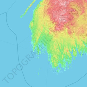
Name: Yarmouth topographic map, elevation, terrain.
Location: Yarmouth, Yarmouth County, Nova Scotia, B0W 2X0, Canada (43.21534 -66.55431 44.49534 -65.27431)
Average elevation: 105 ft
Minimum elevation: -3 ft
Maximum elevation: 712 ft
Other topographic maps
Click on a map to view its topography, its elevation and its terrain.
Cape Breton Island
The island is characterized by a number of elevations of ancient crystalline and metamorphic rock rising up from the south to the north, and contrasted with eroded lowlands. The bedrock of blocks that developed in different places around the globe, at different times, and then were fused together via tectonics.
Average elevation: 217 ft
Kejimkujik National Park Seaside
Canada > Nova Scotia > Queens County > Port Joli
Average elevation: 30 ft
Princton Heights Park
Canada > Nova Scotia > Municipality of Colchester > Salmon River
Average elevation: 194 ft
Halifax Stanfield International Airport
Canada > Nova Scotia > Halifax County > Goffs
Average elevation: 387 ft
Cross Mountain Road
Canada > Nova Scotia > Municipality of the County of Cumberland
Average elevation: 778 ft
Margaret Boone Memorial Park
Canada > Nova Scotia > Cape Breton Regional Municipality > Dominion
Average elevation: 43 ft
Bras d'Or Lake
Canada > Nova Scotia > Municipality of the County of Richmond > Red Islands
Average elevation: 95 ft
Cary Rocks Cove
Canada > Nova Scotia > Cape Breton Regional Municipality > Main-à-Dieu
Average elevation: 10 ft
Williamsdale
Canada > Nova Scotia > Municipality of the County of Cumberland
Average elevation: 630 ft
Town of Bridgewater
Canada > Nova Scotia > Lunenburg County
Bridgewater spans the width of the LaHave River Valley and is dominated by hills that lead down to the river. Elevations range from 5 m above sea level at the river, to nearly 110 m at the southwestern border. Like much of Southern Nova Scotia, the surrounding area is characterized by rolling drumlins formed…
Average elevation: 184 ft
Their Light Shall Always Shine Memorial Park
Canada > Nova Scotia > Municipality of Pictou County > Priestville
Average elevation: 105 ft
Flat Rock
Canada > Nova Scotia > Municipality of the County of Richmond > Grand River
Average elevation: 16 ft
Loch Katrine
Canada > Nova Scotia > Municipality of the County of Antigonish
Average elevation: 413 ft
Sable Island
Canada > Nova Scotia > Halifax County > Sable Island
Sable Island is a narrow, crescent-shaped sandbar with a surface area estimated around 34 km2 (13 sq mi). Despite being approximately 43.15 km (26.81 mi) long, it is only 1.21 km (0.75 mi) across at its widest point. The maximum elevation is about 30 m (98 ft). The long crescent-shaped island rises gently from…
Average elevation: 0 ft
Pleasant Valley
Canada > Nova Scotia > Municipality of the County of Antigonish
Average elevation: 548 ft
Sutherlands Lake
Canada > Nova Scotia > Guysborough County > Lower Caledonia
Average elevation: 476 ft
Torbrook Mines
Canada > Nova Scotia > Municipality of the County of Annapolis
Average elevation: 217 ft