
Monroe County topographic map
Interactive map
Click on the map to display elevation.
About this map
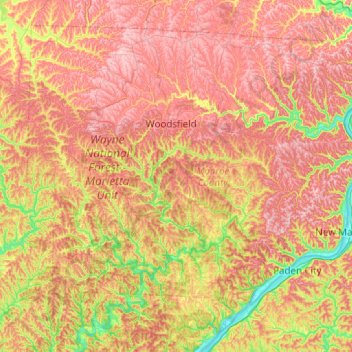
Name: Monroe County topographic map, elevation, terrain.
Location: Monroe County, Ohio, United States (39.53978 -81.31910 39.86948 -80.82128)
Average elevation: 1,020 ft
Minimum elevation: 600 ft
Maximum elevation: 1,381 ft
Ohio trails, hiking, mountain biking, running and outdoor activities
Other topographic maps
Click on a map to view its topography, its elevation and its terrain.
Columbus
United States > Ohio > Franklin County > Columbus
The confluence of the Scioto and Olentangy rivers is just north-west of Downtown Columbus. Several smaller tributaries course through the Columbus metropolitan area, including Alum Creek, Big Walnut Creek, and Darby Creek. Columbus is considered to have relatively flat topography thanks to a large glacier that…
Average elevation: 837 ft
Little Mussy Lake
United States > Ohio > Portage County > Rootstown Township
Average elevation: 1,083 ft
Nature Center at The Summit
United States > Ohio > Hamilton County > Cincinnati
Average elevation: 568 ft
Cuyahoga Valley National Park
United States > Ohio > Cuyahoga County > Independence
Average elevation: 686 ft
Waterloo State Wildlife Management Area
United States > Ohio > Athens County
Average elevation: 876 ft
Schoenbrunn Estates
United States > Ohio > Tuscarawas County > New Philadelphia
Average elevation: 928 ft
French Park
United States > Ohio > Hamilton County > Amberley Village > Rolling Knolls Estate
Average elevation: 771 ft
Pine Ridge Trailer Park
United States > Ohio > Lorain County > North Ridgeville
Average elevation: 748 ft
Nature Center at The Summit
United States > Ohio > Hamilton County > Cincinnati
Average elevation: 568 ft