
New Zealand topographic map
Interactive map
Click on the map to display elevation.
About this map
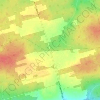
Name: New Zealand topographic map, elevation, terrain.
Location: New Zealand, Kings County, Prince Edward Island, Canada (46.39999 -62.32304 46.41999 -62.30304)
Average elevation: 187 ft
Minimum elevation: 79 ft
Maximum elevation: 253 ft
Other topographic maps
Click on a map to view its topography, its elevation and its terrain.
Springhill
Canada > Prince Edward Island > Rural Municipality of Central Prince
Average elevation: 98 ft
Hunter River
Canada > Prince Edward Island > Rural Municipality of Hunter River
Average elevation: 171 ft
Freeland
Canada > Prince Edward Island > Rural Municipality of Lot 11 and Area
Average elevation: 33 ft
Oultons Island
Canada > Prince Edward Island > Rural Municipality of Lot 11 and Area
Average elevation: 3 ft
Inverness
Canada > Prince Edward Island > Rural Municipality of Central Prince > Inverness
Average elevation: 39 ft
Rural Municipality of Tyne Valley
Canada > Prince Edward Island > Prince County > Rural Municipality of Tyne Valley
Average elevation: 49 ft
Clyde River
Canada > Prince Edward Island > Rural Municipality of Clyde River
The Stone House was built from Island sandstone in 1842, located adjacent to the Trans Canada High Way in Clyde River, PEI. In 1843, the property was purchased by Ambrose Lane and the house was used as hunting lodge. After the passing of the owner in 1853, the house had various owners. In the 1970s the house…
Average elevation: 89 ft