Geolocate

Spring Branch topographic map

Interactive map

Click on the map to display elevation.

About this map

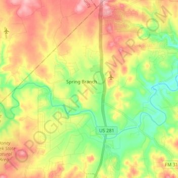
Name: Spring Branch topographic map, elevation, terrain.

Location: Spring Branch, Comal County, Texas, United States (29.82779 -98.44823 29.94236 -98.38294)

Average elevation: 1,142 ft

Minimum elevation: 935 ft

Maximum elevation: 1,362 ft

Comal County trails, hiking, mountain biking, running and outdoor activities

Other topographic maps

Click on a map to view its topography, its elevation and its terrain.

Canyon Lake

United States > Texas > Comal County

Average elevation: 971 ft

Canyon Lake Dam

United States > Texas > Comal County

Average elevation: 902 ft

Cranes Mill

United States > Texas > Comal County

Average elevation: 1,010 ft

Fair Oaks Ranch

United States > Texas > Comal County

Average elevation: 1,342 ft

Oak Run

United States > Texas > Comal County > New Braunfels

Average elevation: 833 ft

Cranes Mill

United States > Texas > Comal County

Average elevation: 1,184 ft

Garden Ridge

United States > Texas > Comal County

Average elevation: 863 ft

Smithson Valley

United States > Texas > Comal County

Average elevation: 1,273 ft

Woodrow

United States > Texas > Comal County > New Braunfels

Average elevation: 719 ft

Glenbrook

United States > Texas > Comal County > New Braunfels

Average elevation: 659 ft

Freiheit

United States > Texas > Comal County > New Braunfels

Average elevation: 669 ft

Royal Forest

United States > Texas > Comal County > Royal Forest

Average elevation: 1,004 ft

Fischer

United States > Texas > Comal County

Average elevation: 1,191 ft

Summerwood

United States > Texas > Comal County > New Braunfels > Summerwood

Average elevation: 656 ft