Geolocate

Fair Oaks Ranch topographic map

Click on the map to display elevation.

About this map

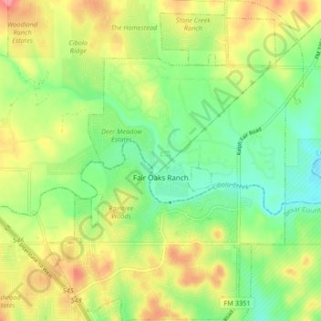
Name: Fair Oaks Ranch topographic map, elevation, terrain.

Location: Fair Oaks Ranch, Comal County, Texas, United States (29.71375 -98.67273 29.78513 -98.60687)

Average elevation: 1,342 ft

Minimum elevation: 1,211 ft

Maximum elevation: 1,519 ft

Comal County trails, hiking, mountain biking, running and outdoor activities

Other topographic maps

Click on a map to view its topography, its elevation and its terrain.

Bulverde

United States > Texas > Comal County

Average elevation: 1,194 ft

villas pool

United States > Texas > Comal County > Bulverde

Average elevation: 1,240 ft

Spring Branch

United States > Texas > Comal County

Average elevation: 1,142 ft

Fischer

United States > Texas > Comal County

Average elevation: 1,191 ft

Royal Forest

United States > Texas > Comal County > Royal Forest

Average elevation: 1,004 ft

Glenbrook

United States > Texas > Comal County > New Braunfels

Average elevation: 659 ft

Freiheit

United States > Texas > Comal County > New Braunfels

Average elevation: 669 ft

Smithson Valley

United States > Texas > Comal County

Average elevation: 1,273 ft

Woodrow

United States > Texas > Comal County > New Braunfels

Average elevation: 719 ft

Cranes Mill

United States > Texas > Comal County

Average elevation: 1,184 ft

Oak Run

United States > Texas > Comal County > New Braunfels

Average elevation: 833 ft

Cranes Mill

United States > Texas > Comal County

Average elevation: 1,010 ft

New Braunfels

United States > Texas > Comal County

Average elevation: 748 ft

Gear up for your next adventure:

📦Dry Bags Set - Waterproof storage for electronics and clothes
🦺Reflective Outdoor Gear - Safety gear for low‑light conditions
🧴Hand Sanitizer - Keep hands clean while hiking
🪄Magnetic Compass - Accurate compass for navigation
🧭GPS Watch Accessories - Bands and chargers for GPS watches

As an Amazon Associate, this site earns from qualifying purchases at no extra cost to you.