Geolocate

Fischer topographic map

Click on the map to display elevation.

About this map

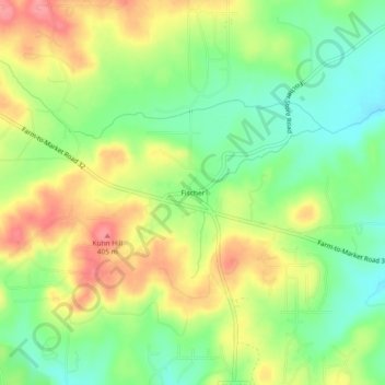
Name: Fischer topographic map, elevation, terrain.

Location: Fischer, Comal County, Texas, 78623, United States (29.95688 -98.28585 29.99688 -98.24585)

Average elevation: 1,191 ft

Minimum elevation: 1,063 ft

Maximum elevation: 1,339 ft

Comal County trails, hiking, mountain biking, running and outdoor activities

Other topographic maps

Click on a map to view its topography, its elevation and its terrain.

Bulverde

United States > Texas > Comal County

Average elevation: 1,194 ft

Fair Oaks Ranch

United States > Texas > Comal County

Average elevation: 1,342 ft

villas pool

United States > Texas > Comal County > Bulverde

Average elevation: 1,240 ft

Spring Branch

United States > Texas > Comal County

Average elevation: 1,142 ft

Canyon Lake Dam

United States > Texas > Comal County

Average elevation: 902 ft

New Braunfels

United States > Texas > Comal County

Average elevation: 748 ft

Gear up for your next adventure:

🥾Men's Hiking Boots - Durable, waterproof footwear for rugged terrain and steep inclines
🪄Magnetic Compass - Accurate compass for navigation
🌄Hiking Binoculars - Compact binoculars for scenic views and trail spotting
🗺️Topographic Maps - Detailed topo maps for hiking, exploring and outdoor navigation
🧢Outdoor Hiking Hat - Sun protection hat for outdoor explorers

As an Amazon Associate, this site earns from qualifying purchases at no extra cost to you.