
Make a donation
San Bartolo topographic map
Interactive map
Click on the map to display elevation.


About this map
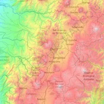
Name: San Bartolo topographic map, elevation, terrain.
Location: San Bartolo, Pichincha, 170148, Ecuador (-0.89899 -79.17423 0.38101 -77.89423)
Average elevation: 8,373 ft
Minimum elevation: 659 ft
Maximum elevation: 19,088 ft
Other topographic maps
Click on a map to view its topography, its elevation and its terrain.
Pedro Vicente Maldonado
Ecuador > Pichincha > Pedro Vicente Maldonado
Pedro Vicente Maldonado is a city in the Pichincha province of Ecuador and the capital of Pedro Vicente Maldonado Canton. It is located on the right bank of the Caoní River, to the northwest of the province, on the outer flanks of the western cordillera of the Andes, at an altitude of 605 m and with a rainy…
Average elevation: 1,768 ft
Cumbaya
Ecuador > Pichincha > Quito Canton
At an elevation of 2200 m (7200 ft) above sea level, Cumbayá is lower than Quito and its climate is about 2 to 5 degrees Celsius warmer. Weather is semi tropical year-round, with a short rainy season.
Average elevation: 8,018 ft
Machachi
Machachi is located to the south of the capital of Ecuador, Quito. It is a very beautiful city surrounded by the volcanos Atacazo, Corazon, Rumiñahui, Illinizas peaks, Viudita hill, Pasochoa, Sincholagua and is also owns part of the Cotopaxi volcano, a great active volcano which measures 5,897 m (19,347 ft)…
Average elevation: 9,639 ft
Volcán Cotopaxi
Ecuador > Pichincha > Machachi > Machachi
In the late 20th century, summiting Cotopaxi became a major tourist draw. The José F. Ribas Refuge (Refugio José Félix Ribas) was built in 1971 at an elevation of 4,864 m (15,960 ft) and enlarged in 2005.
Average elevation: 16,473 ft