
Iron Hill topographic map
Interactive map
Click on the map to display elevation.
About this map
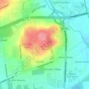
Name: Iron Hill topographic map, elevation, terrain.
Location: Iron Hill, New Castle County, Delaware, 19714, United States (39.63868 -75.75191 39.63878 -75.75181)
Average elevation: 144 ft
Minimum elevation: 39 ft
Maximum elevation: 351 ft
Delaware trails, hiking, mountain biking, running and outdoor activities
Other topographic maps
Click on a map to view its topography, its elevation and its terrain.
Brandywine Creek State Park
United States > Delaware > New Castle County > Talleyville
Average elevation: 305 ft
Delmar Park
United States > Delaware > Sussex County > Delmar > Holly Oak Mobile Home Park
Average elevation: 52 ft
Kent Acres
United States > Delaware > Kent County > Kent Acres > Woods Manor East
Average elevation: 26 ft
Bellefonte
United States > Delaware > New Castle County > Bellefonte > KynLyn Apartments
Average elevation: 115 ft