
Sullivan County topographic map
Click on the map to display elevation.
About this map
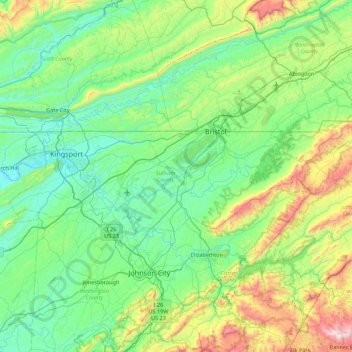
Name: Sullivan County topographic map, elevation, terrain.
Location: Sullivan County, East Tennessee, Tennessee, United States (36.39462 -82.70094 36.61621 -81.82668)
Average elevation: 2,051 ft
Minimum elevation: 1,135 ft
Maximum elevation: 5,433 ft
Tennessee trails, hiking, mountain biking, running and outdoor activities
Other topographic maps
Click on a map to view its topography, its elevation and its terrain.
Henderson Springs
United States > Tennessee > Sevier County > Pigeon Forge
Average elevation: 1,079 ft
Eastdale
United States > Tennessee > Hamilton County > Chattanooga > Ridgeside
Average elevation: 778 ft
Ridgedale
United States > Tennessee > Hamilton County > Chattanooga > Ridgeside
Average elevation: 768 ft
Barfield Crescent Park
United States > Tennessee > Rutherford County > Murfreesboro
Average elevation: 659 ft
Stonehenge Estates
United States > Tennessee > Williamson County > Brentwood
Average elevation: 840 ft
Cherokee Dam - Saddle Dam No. 1
United States > Tennessee > Jefferson County
Average elevation: 1,053 ft
Brainerd
United States > Tennessee > Hamilton County > Chattanooga > Ridgeside
Average elevation: 768 ft
Millersville City Park
United States > Tennessee > Robertson County > Millersville
Average elevation: 853 ft