
New Delhi topographic map
Interactive map
Click on the map to display elevation.
About this map
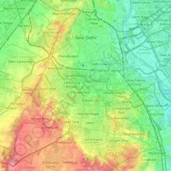
Name: New Delhi topographic map, elevation, terrain.
Location: New Delhi, Delhi, India (28.48122 77.05037 28.64568 77.25514)
Average elevation: 755 ft
Minimum elevation: 633 ft
Maximum elevation: 951 ft
Other topographic maps
Click on a map to view its topography, its elevation and its terrain.
Yamuna River
The source of Yamuna lies in the Yamunotri Glacier at an elevation of 6,387 metres (20,955 ft), on the south-western slopes of Banderpooch peaks, which lie in the Mussoorie range of the Lower Himalayas, north of Haridwar in Uttarkashi district, Uttarakhand. Yamunotri temple, a shrine dedicated to the goddess…
Average elevation: 676 ft