
Make a donation
Gear up for your next adventure:
As an Amazon Associate, this site earns from qualifying purchases at no extra cost to you.
Miami topographic map
Click on the map to display elevation.
Make a donation
Gear up for your next adventure:
As an Amazon Associate, this site earns from qualifying purchases at no extra cost to you.
Miami
Miami is characterized by its unique topography, which features a broad coastal plain lying between the expansive Everglades to the west and the tranquil waters of Biscayne Bay to the east. The average elevation across the city is approximately 16 feet (5 meters) above sea level, with some areas dipping slightly below this average, especially along the coastal zones. The highest elevations can be found along the Miami Rock Ridge, which runs beneath much of the eastern metropolitan area, reaching a maximum of about 43 feet (13 meters) in certain locations. This flat landscape is interspersed with numerous natural and artificial barrier islands, the largest of which include Miami Beach and South Beach, contributing to the city's vibrant coastal ecosystem. The nearby Gulf Stream, situated around 15 miles offshore, influences Miami's mild climate, making it a year-round destination.
Make a donation
Gear up for your next adventure:
As an Amazon Associate, this site earns from qualifying purchases at no extra cost to you.
About this map
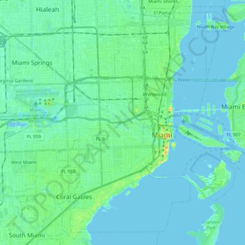
Name: Miami topographic map, elevation, terrain.
Location: Miami, Miami-Dade County, Florida, United States (25.70905 -80.31976 25.85578 -80.13916)
Average elevation: 16 ft
Minimum elevation: -7 ft
Maximum elevation: 115 ft
Miami-Dade County trails, hiking, mountain biking, running and outdoor activities
Make a donation
Gear up for your next adventure:
As an Amazon Associate, this site earns from qualifying purchases at no extra cost to you.
Other topographic maps
Click on a map to view its topography, its elevation and its terrain.
Medley Lakeside Retirement Community
United States > Florida > Miami-Dade County > Medley
Average elevation: 20 ft
Andover Golf Estates
United States > Florida > Miami-Dade County > Miami Gardens
Average elevation: 23 ft
Make a donation
Gear up for your next adventure:
As an Amazon Associate, this site earns from qualifying purchases at no extra cost to you.
Goldcoaster Mobile Home Park
United States > Florida > Miami-Dade County > Homestead
Average elevation: 10 ft
Cloverleaf Park
United States > Florida > Miami-Dade County > Miami Gardens > Norland
Average elevation: 26 ft
Make a donation
Gear up for your next adventure:
As an Amazon Associate, this site earns from qualifying purchases at no extra cost to you.
Aquarius Mobile Home Park
United States > Florida > Miami-Dade County > Homestead
Average elevation: 13 ft
Key Biscayne
United States > Florida > Miami-Dade County
Key Biscayne lies south of Miami Beach and east of Miami. The village is connected to Miami via the Rickenbacker Causeway, originally built in 1947. Because of its low elevation and direct exposure to the Atlantic Ocean, it is usually among the first Miami areas to be evacuated before an oncoming hurricane.
Average elevation: 10 ft
Make a donation
Gear up for your next adventure:
As an Amazon Associate, this site earns from qualifying purchases at no extra cost to you.
Harris Field
United States > Florida > Miami-Dade County > Homestead > Four Seasons Mobile Home Park
Average elevation: 13 ft
Make a donation
Gear up for your next adventure:
As an Amazon Associate, this site earns from qualifying purchases at no extra cost to you.
Hibiscus Point Mobile Home Park
United States > Florida > Miami-Dade County > Hialeah
Average elevation: 26 ft
Make a donation
Gear up for your next adventure:
As an Amazon Associate, this site earns from qualifying purchases at no extra cost to you.
West Little River
United States > Florida > Miami-Dade County > Miami > West Little River
Average elevation: 23 ft
Strawberry Village Trailer Park
United States > Florida > Miami-Dade County > Hialeah
Average elevation: 20 ft
Make a donation
Gear up for your next adventure:
As an Amazon Associate, this site earns from qualifying purchases at no extra cost to you.
Make a donation
Gear up for your next adventure:
As an Amazon Associate, this site earns from qualifying purchases at no extra cost to you.
Silver Court Trailer Park
United States > Florida > Miami-Dade County > Miami
Average elevation: 30 ft
Harbor Island
United States > Florida > Miami-Dade County > North Bay Village
Average elevation: 10 ft
Baywinds Apartments
United States > Florida > Miami-Dade County > North Miami
Average elevation: 23 ft
Make a donation
Gear up for your next adventure:
As an Amazon Associate, this site earns from qualifying purchases at no extra cost to you.
Miami
United States > Florida > Miami-Dade County
Miami and its suburbs are located on a broad plain between the Everglades to the west and Biscayne Bay to the east, which extends from Lake Okeechobee southward to Florida Bay. The elevation of the area averages at around 6 ft (1.8 m) above sea level in most neighborhoods, especially near the coast. The…
Average elevation: 13 ft
Bal Harbor Beach
United States > Florida > Miami-Dade County > Bal Harbour Village
Average elevation: 10 ft
Make a donation
Gear up for your next adventure:
As an Amazon Associate, this site earns from qualifying purchases at no extra cost to you.
Make a donation
Gear up for your next adventure:
As an Amazon Associate, this site earns from qualifying purchases at no extra cost to you.
Make a donation
Gear up for your next adventure:
As an Amazon Associate, this site earns from qualifying purchases at no extra cost to you.
Make a donation
Gear up for your next adventure:
As an Amazon Associate, this site earns from qualifying purchases at no extra cost to you.
Strawberry Village Trailer Park
United States > Florida > Miami-Dade County > Hialeah
Average elevation: 20 ft
Make a donation
Gear up for your next adventure:
As an Amazon Associate, this site earns from qualifying purchases at no extra cost to you.
West Little River
United States > Florida > Miami-Dade County > West Little River
Average elevation: 23 ft
Make a donation
Gear up for your next adventure:
As an Amazon Associate, this site earns from qualifying purchases at no extra cost to you.
South Miami Heights
United States > Florida > Miami-Dade County > South Miami Heights
Average elevation: 20 ft
Silver Court Trailer Park
United States > Florida > Miami-Dade County > Miami
Average elevation: 30 ft
Make a donation
Gear up for your next adventure:
As an Amazon Associate, this site earns from qualifying purchases at no extra cost to you.