
Prairie Village topographic map
Interactive map
Click on the map to display elevation.
About this map
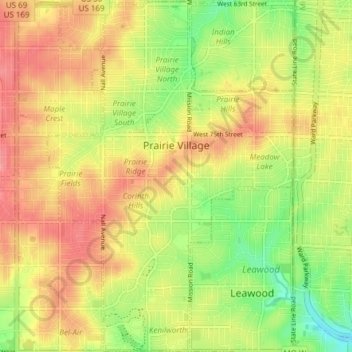
Name: Prairie Village topographic map, elevation, terrain.
Location: Prairie Village, Johnson County, Kansas, United States (38.95677 -94.66109 39.01564 -94.60787)
Average elevation: 984 ft
Minimum elevation: 837 ft
Maximum elevation: 1,106 ft
Johnson County trails, hiking, mountain biking, running and outdoor activities
Other topographic maps
Click on a map to view its topography, its elevation and its terrain.
Overland Park Arboretum and Botanical Gardens
United States > Kansas > Johnson County > Overland Park
Average elevation: 1,001 ft
Elmhurst
United States > Kansas > Johnson County > Overland Park > Elmhurst
Average elevation: 1,027 ft