
Chatburn topographic map
Interactive map
Click on the map to display elevation.
About this map
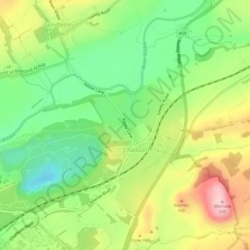
Name: Chatburn topographic map, elevation, terrain.
Location: Chatburn, Ribble Valley, Lancashire, England, United Kingdom (53.88334 -2.37635 53.90607 -2.32850)
Average elevation: 325 ft
Minimum elevation: 43 ft
Maximum elevation: 705 ft
Other topographic maps
Click on a map to view its topography, its elevation and its terrain.
Hesketh Lane
United Kingdom > England > Lancashire > Ribble Valley
Hesketh Lane, Chipping, Ribble Valley, Lancashire, England, PR3 2TH, United Kingdom
Average elevation: 430 ft
Mellor
United Kingdom > England > Lancashire > Ribble Valley
Mellor, Ribble Valley, Lancashire, England, United Kingdom
Average elevation: 456 ft
Read
United Kingdom > England > Lancashire > Ribble Valley
Read, Ribble Valley, Lancashire, England, United Kingdom
Average elevation: 374 ft
Gisburn
United Kingdom > England > Lancashire > Ribble Valley
Gisburn, Ribble Valley, Lancashire, England, United Kingdom
Average elevation: 525 ft
Old Langho
United Kingdom > England > Lancashire > Ribble Valley > Brockhall Village
Old Langho, Billington and Langho, Brockhall Village, Ribble Valley, Lancashire, England, BB6 8AP, United Kingdom
Average elevation: 243 ft
Billington and Langho
United Kingdom > England > Lancashire > Ribble Valley > Brockhall Village
Billington and Langho, Brockhall Village, Ribble Valley, Lancashire, England, United Kingdom, Chew Bank Wood
Average elevation: 190 ft
Brungerley Park
United Kingdom > England > Lancashire > Ribble Valley > Clitheroe > Waddington
Brungerley Park, Clitheroe, Waddington, Ribble Valley, Lancashire, England, United Kingdom
Average elevation: 253 ft
Billington
United Kingdom > England > Lancashire > Ribble Valley
Billington, Ribble Valley, Lancashire, England, BB7 9NG, United Kingdom
Average elevation: 292 ft
Whitewell
United Kingdom > England > Lancashire > Ribble Valley
Whitewell, Bowland Forest Low, Ribble Valley, Lancashire, England, BB7 3AT, United Kingdom
Average elevation: 604 ft
Horton
United Kingdom > England > Lancashire > Ribble Valley
Horton, Ribble Valley, Lancashire, England, BD23 3JT, United Kingdom
Average elevation: 495 ft
Ribchester
United Kingdom > England > Lancashire > Ribble Valley
Ribchester, Ribble Valley, Lancashire, England, United Kingdom
Average elevation: 364 ft
Dutton
United Kingdom > England > Lancashire > Ribble Valley
Dutton, Ribble Valley, Lancashire, England, United Kingdom
Average elevation: 440 ft
Sabden
United Kingdom > England > Lancashire > Ribble Valley
Sabden, Ribble Valley, Lancashire, England, United Kingdom
Average elevation: 774 ft
Newsholme
United Kingdom > England > Lancashire > Ribble Valley
Newsholme, Ribble Valley, Lancashire, England, United Kingdom
Average elevation: 459 ft
Wilpshire
United Kingdom > England > Lancashire > Ribble Valley
Wilpshire, Ribble Valley, Lancashire, England, United Kingdom
Average elevation: 489 ft
Clitheroe
United Kingdom > England > Lancashire > Ribble Valley
Clitheroe, Ribble Valley, Lancashire, England, United Kingdom
Average elevation: 276 ft
Bowland Knotts
United Kingdom > England > Lancashire > Ribble Valley
Bowland Knotts, Ribble Valley, Lancashire, North West England, England, LA2 8HA, United Kingdom
Average elevation: 1,135 ft
Barrow
United Kingdom > England > Lancashire > Ribble Valley
Barrow, Ribble Valley, Lancashire, England, United Kingdom
Average elevation: 276 ft
Longridge
United Kingdom > England > Lancashire > Ribble Valley
Longridge, Ribble Valley, Lancashire, England, United Kingdom
Average elevation: 292 ft
Whalley
United Kingdom > England > Lancashire > Ribble Valley
Whalley, Ribble Valley, Lancashire, England, United Kingdom
Average elevation: 312 ft
Mellor Brook
United Kingdom > England > Lancashire > Ribble Valley > Mellor Brook
Mellor Brook, Ribble Valley, Lancashire, North West England, England, BB2 7PR, United Kingdom
Average elevation: 348 ft
Chipping
United Kingdom > England > Lancashire > Ribble Valley
Chipping, Ribble Valley, Lancashire, England, United Kingdom
Average elevation: 636 ft
Jamacia Wood
United Kingdom > England > Lancashire > Ribble Valley > Langho
Jamacia Wood, Billington and Langho, Langho, Ribble Valley, Lancashire, North West England, England, United Kingdom
Average elevation: 328 ft
Slaidburn
United Kingdom > England > Lancashire > Ribble Valley
Slaidburn, Ribble Valley, Lancashire, England, United Kingdom
Average elevation: 823 ft
Newton
United Kingdom > England > Lancashire > Ribble Valley
Newton, Ribble Valley, Lancashire, England, United Kingdom
Average elevation: 732 ft
West Bradford
United Kingdom > England > Lancashire > Ribble Valley
West Bradford, Ribble Valley, Lancashire, England, United Kingdom
Average elevation: 620 ft
Waddington
United Kingdom > England > Lancashire > Ribble Valley > Waddington
Waddington, Ribble Valley, Lancashire, North West England, England, United Kingdom
Average elevation: 538 ft