
Dallas topographic map
Interactive map
Click on the map to display elevation.
About this map
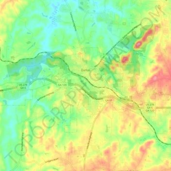
Name: Dallas topographic map, elevation, terrain.
Location: Dallas, Paulding County, Georgia, United States (33.88875 -84.89893 33.94127 -84.78327)
Average elevation: 1,007 ft
Minimum elevation: 827 ft
Maximum elevation: 1,266 ft
On April 4, 1977, near the site marker for the Battle of New Hope Church, the forced landing of Southern Airways Flight 242 occurred. The passenger jetliner, a McDonnell Douglas DC-9 with 81 passengers and 4 crew members, was flying from Northwest Alabama Regional Airport to Atlanta Municipal Airport. Upon descending in altitude to prepare for landing in Atlanta, the jetliner started to fly through an intense thunderstorm near Rome, Georgia. Because of the extreme amounts of water and hail that were ingested by the jet's engines, both of the Pratt & Whitney JT8D-7A turbojet engines were damaged and underwent flameout. With the engines unable to restart, the flight's crew began gliding in hopes of reaching a nearby airport. Upon finding out that there were no nearby airports to perform a landing, the crew found a straight section of rural road in Dallas, Georgia to try and land. As the plane began to land, it clipped a gas station, convenience store, and other buildings, resulting in the plane to lose control of landing and ultimately crash, resulting in hull loss. Both pilots and 61 passengers were killed by impact forces and fire. Nine people on the ground were also killed.
Other topographic maps
Click on a map to view its topography, its elevation and its terrain.
Brownsville
United States > Georgia > Paulding County
Brownsville, Paulding County, Georgia, 30134, United States
Average elevation: 981 ft
Cross Roads
United States > Georgia > Paulding County
Cross Roads, Paulding County, Georgia, United States
Average elevation: 961 ft
Nebo
United States > Georgia > Paulding County > Hiram
Nebo, Hiram, Paulding County, Georgia, 30140, United States
Average elevation: 1,040 ft
New Hope
United States > Georgia > Paulding County
New Hope, Country Acres, Paulding County, Georgia, 30132, United States
Average elevation: 1,040 ft
Braswell
United States > Georgia > Paulding County
Braswell, Paulding County, Georgia, United States
Average elevation: 1,079 ft
Yorkville
United States > Georgia > Paulding County
Yorkville, Paulding County, Georgia, 30153, United States
Average elevation: 1,280 ft
Ash
United States > Georgia > Paulding County
Ash, Paulding County, Georgia, 30140, United States
Average elevation: 1,047 ft
Hiram
United States > Georgia > Paulding County
Hiram, Paulding County, Georgia, United States
Average elevation: 1,004 ft
Hickory Gap
United States > Georgia > Paulding County > Hickory Gap
Hickory Gap, Paulding County, Georgia, 30140, United States
Average elevation: 1,043 ft
Ray Mountain
United States > Georgia > Paulding County
Ray Mountain, Paulding County, Georgia, 30132, United States
Average elevation: 1,004 ft