Geolocate

Hiram topographic map

Click on the map to display elevation.

About this map

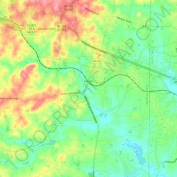
Name: Hiram topographic map, elevation, terrain.

Location: Hiram, Paulding County, Georgia, United States (33.83062 -84.83364 33.91318 -84.72438)

Average elevation: 1,004 ft

Minimum elevation: 879 ft

Maximum elevation: 1,198 ft

Paulding County trails, hiking, mountain biking, running and outdoor activities

Other topographic maps

Click on a map to view its topography, its elevation and its terrain.

Yorkville

United States > Georgia > Paulding County

Average elevation: 1,289 ft

Pumpkin

United States > Georgia > Paulding County

Average elevation: 984 ft

Ray Mountain

United States > Georgia > Paulding County

Average elevation: 1,004 ft

Ash

United States > Georgia > Paulding County

Average elevation: 1,047 ft

Nebo

United States > Georgia > Paulding County > Hiram

Average elevation: 1,040 ft

Brownsville

United States > Georgia > Paulding County

Average elevation: 981 ft

Gear up for your next adventure:

🛠️Outdoor Gear Repair Kit - Essential tools to fix gear on the trail
🕶️Glacier Sunglasses - Side shields to protect eyes from high-altitude snow glare
🏕️Family Camping Gear - Essentials for group camping trips
🩹Survival Bandages - High‑quality bandages for emergencies
🔋Rechargeable Batteries - Power up your outdoor devices

As an Amazon Associate, this site earns from qualifying purchases at no extra cost to you.