
Allentown topographic map
Interactive map
Click on the map to display elevation.
About this map
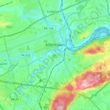
Name: Allentown topographic map, elevation, terrain.
Location: Allentown, Lehigh County, Pennsylvania, United States (40.54998 -75.54800 40.63601 -75.41925)
Average elevation: 423 ft
Minimum elevation: 217 ft
Maximum elevation: 1,037 ft
Lehigh County trails, hiking, mountain biking, running and outdoor activities
Other topographic maps
Click on a map to view its topography, its elevation and its terrain.
East Texas
United States > Pennsylvania > Lehigh County > Lower Macungie Township
Average elevation: 413 ft
South Mountain
United States > Pennsylvania > Lehigh County > Upper Saucon
Unlike Blue Mountain to its north, South Mountain does not follow a straight geographic line. The mountain ranges in elevation between 500 and 1,300 feet (150 and 400 m) above sea level. The ridge is made of metamorphic rocks and gneiss, which date to the Precambrian era and range from about 570 million to…
Average elevation: 502 ft
Hillside
United States > Pennsylvania > Lehigh County > South Whitehall Township
Average elevation: 499 ft
South Mountain
United States > Pennsylvania > Lehigh County > Upper Saucon
Unlike Blue Mountain to its north, South Mountain does not follow a straight geographic line. The mountain ranges in elevation between 500 and 1,300 feet (150 and 400 m) above sea level. The ridge is made of metamorphic rocks and gneiss, which date to the Precambrian era and range from about 570 million to…
Average elevation: 502 ft
Saegersville
United States > Pennsylvania > Lehigh County > Heidelberg Township
Average elevation: 682 ft
North Fogelsville
United States > Pennsylvania > Lehigh County > Upper Macungie Township > Fogelsville
Average elevation: 541 ft
Weilersville
United States > Pennsylvania > Lehigh County > Lower Macungie Township
Average elevation: 413 ft
Fogelsville
United States > Pennsylvania > Lehigh County > Upper Macungie Township
Average elevation: 509 ft
Leather Corner Post
United States > Pennsylvania > Lehigh County > Lowhill Township
Average elevation: 584 ft
Orefield
United States > Pennsylvania > Lehigh County > North Whitehall Township
Average elevation: 463 ft
Cherry Hill
United States > Pennsylvania > Lehigh County > Upper Macungie Township
Average elevation: 479 ft
Jordan Valley
United States > Pennsylvania > Lehigh County > Heidelberg Township
Average elevation: 699 ft
Ormrod
United States > Pennsylvania > Lehigh County > North Whitehall Township
Average elevation: 486 ft
East Texas
United States > Pennsylvania > Lehigh County > Lower Macungie Township
Average elevation: 413 ft
Wescosville
United States > Pennsylvania > Lehigh County > Lower Macungie Township
Average elevation: 420 ft
Crackersport
United States > Pennsylvania > Lehigh County > South Whitehall Township
Average elevation: 453 ft
Weidasville
United States > Pennsylvania > Lehigh County > Lowhill Township > Weidasville
Average elevation: 558 ft