
Stanford topographic map
Interactive map
Click on the map to display elevation.
About this map
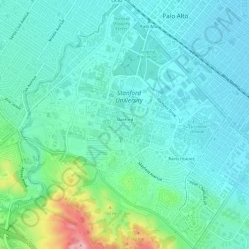
Name: Stanford topographic map, elevation, terrain.
Location: Stanford, Santa Clara County, California, United States (37.40633 -122.19151 37.44691 -122.14952)
Average elevation: 131 ft
Minimum elevation: 26 ft
Maximum elevation: 522 ft
Santa Clara County trails, hiking, mountain biking, running and outdoor activities
Other topographic maps
Click on a map to view its topography, its elevation and its terrain.
Santa Cruz Mountains
United States > California > Santa Clara County
The Santa Cruz Mountains are a region of great biological diversity, encompassing cool, moist coastal ecosystems as well as warm, dry chaparral. Much of the area in the Santa Cruz mountains is considered temperate rainforest. In valleys and moist ocean-facing slopes some of the southernmost coast redwoods…
Average elevation: 755 ft
Pacheco Pass
United States > California > Santa Clara County
Pacheco Pass, elevation 1,368 ft (417 m), is a low mountain pass located in the Diablo Range in southeastern Santa Clara County, California. It is the main route through the hills separating the Santa Clara Valley and the Central Valley.
Average elevation: 1,394 ft
Los Gatos Creek County Park
United States > California > Santa Clara County > Campbell
Average elevation: 246 ft
Camden Pond No. 3
United States > California > Santa Clara County > Campbell
Average elevation: 236 ft
Martial Cottle Park
United States > California > Santa Clara County > San Jose
Average elevation: 171 ft
Creekside Village
United States > California > Santa Clara County > Los Gatos
Average elevation: 545 ft
Katzman Automated Imaging Telescope
United States > California > Santa Clara County
Average elevation: 3,409 ft
Gilroy
United States > California > Santa Clara County > Gilroy
Gilroy is approximately 16 miles (26 km) south of San Jose, California (Bailey Avenue (37.206770, -121.729150) to Monterey/Day Road (37.038210, -121.584480)) on U.S. Route 101 and 19 miles (31 km) inland from the Pacific Coast. Despite its apparent close proximity to San Jose, it is important to note that…
Average elevation: 715 ft
Sierra Vista Open Space Preserve
United States > California > Santa Clara County > San Jose
Average elevation: 1,588 ft
Chemeketa Park
United States > California > Santa Clara County > Redwood Estates
Average elevation: 1,355 ft
Holy City
United States > California > Santa Clara County > Redwood Estates
Average elevation: 1,407 ft
Morgan Hill
United States > California > Santa Clara County > Morgan Hill
Morgan Hill is approximately 39 km (24 mi) south of downtown San Jose, 21 km (13 mi) north of Gilroy, and 24 km (15 mi) inland from the Pacific coast. Lying in a roughly 6 km-wide (4-mi-wide) southern extension of the Santa Clara Valley, it is bounded by the Santa Cruz Mountains to the west and the Diablo…
Average elevation: 476 ft
Vasona Junction
United States > California > Santa Clara County > Los Gatos > Vasona Junction
Average elevation: 292 ft
Deer Creek
United States > California > Santa Clara County > Los Altos Hills
Average elevation: 299 ft
Aldercroft Heights
United States > California > Santa Clara County > Aldercroft Heights
Average elevation: 1,401 ft
Los Altos
United States > California > Santa Clara County > Los Altos > Los Altos
Average elevation: 269 ft
Black Mountain
United States > California > Santa Clara County > Palo Alto
Average elevation: 2,175 ft
Lexington Hills
United States > California > Santa Clara County > Redwood Estates > Lexington Hills
Average elevation: 1,332 ft