
Make a donation
Gear up for your next adventure:
As an Amazon Associate, this site earns from qualifying purchases at no extra cost to you.
Allegany County topographic map
Click on the map to display elevation.
Make a donation
Gear up for your next adventure:
As an Amazon Associate, this site earns from qualifying purchases at no extra cost to you.
Allegany County
Allegany County lies primarily in the Ridge-and-Valley Country of the Appalachian Mountains. It is bordered to the north by the Mason–Dixon line with Pennsylvania, to the south by the Potomac River and West Virginia, to the east by Sideling Hill Creek and Washington County, Maryland, and to the west by a land border with Garrett County, Maryland. The western part of the county contains a portion of the steep Allegheny Front, which marks the transition to the higher-elevation Appalachian Plateau and Allegheny Mountain region. The town of Frostburg is located west of the Front at an elevation of nearly 2,100 feet above sea level, while the county seat of Cumberland, only eight miles away, has an elevation of only 627 feet.
Make a donation
Gear up for your next adventure:
As an Amazon Associate, this site earns from qualifying purchases at no extra cost to you.
About this map
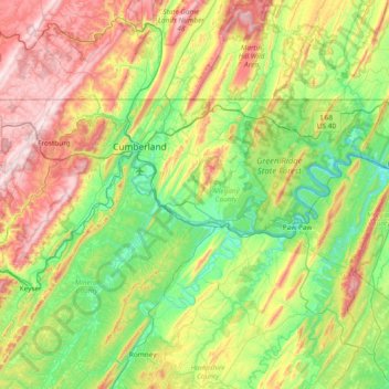
Name: Allegany County topographic map, elevation, terrain.
Location: Allegany County, Maryland, United States (39.43829 -79.06693 39.72303 -78.31331)
Average elevation: 1,283 ft
Minimum elevation: 423 ft
Maximum elevation: 2,969 ft
Maryland trails, hiking, mountain biking, running and outdoor activities
Make a donation
Gear up for your next adventure:
As an Amazon Associate, this site earns from qualifying purchases at no extra cost to you.
Other topographic maps
Click on a map to view its topography, its elevation and its terrain.
Baltimore
United States > Maryland > Baltimore
Baltimore is in north-central Maryland on the Patapsco River close to where it empties into the Chesapeake Bay. The city is also located on the fall line between the Piedmont Plateau and the Atlantic coastal plain, which divides Baltimore into "lower city" and "upper city". The city's elevation ranges from sea…
Average elevation: 213 ft
Make a donation
Gear up for your next adventure:
As an Amazon Associate, this site earns from qualifying purchases at no extra cost to you.
Make a donation
Gear up for your next adventure:
As an Amazon Associate, this site earns from qualifying purchases at no extra cost to you.
Make a donation
Gear up for your next adventure:
As an Amazon Associate, this site earns from qualifying purchases at no extra cost to you.
Make a donation
Gear up for your next adventure:
As an Amazon Associate, this site earns from qualifying purchases at no extra cost to you.
Make a donation
Gear up for your next adventure:
As an Amazon Associate, this site earns from qualifying purchases at no extra cost to you.
Make a donation
Gear up for your next adventure:
As an Amazon Associate, this site earns from qualifying purchases at no extra cost to you.
Make a donation
Gear up for your next adventure:
As an Amazon Associate, this site earns from qualifying purchases at no extra cost to you.
Make a donation
Gear up for your next adventure:
As an Amazon Associate, this site earns from qualifying purchases at no extra cost to you.
Hoye-Crest
United States > Maryland > Garrett County
Hoye-Crest is a summit along Backbone Mountain just inside of Garrett County, Maryland. It is the highest natural point in Maryland at an elevation of 3,360 feet (1,020 m).
Average elevation: 2,910 ft
Londontown Terrace
United States > Maryland > Anne Arundel County > Edgewater
Average elevation: 13 ft
Make a donation
Gear up for your next adventure:
As an Amazon Associate, this site earns from qualifying purchases at no extra cost to you.
Quiet Waters Park
United States > Maryland > Anne Arundel County > Annapolis > Georgetown East
Average elevation: 23 ft
Make a donation
Gear up for your next adventure:
As an Amazon Associate, this site earns from qualifying purchases at no extra cost to you.
Make a donation
Gear up for your next adventure:
As an Amazon Associate, this site earns from qualifying purchases at no extra cost to you.
Make a donation
Gear up for your next adventure:
As an Amazon Associate, this site earns from qualifying purchases at no extra cost to you.
Make a donation
Gear up for your next adventure:
As an Amazon Associate, this site earns from qualifying purchases at no extra cost to you.
Make a donation
Gear up for your next adventure:
As an Amazon Associate, this site earns from qualifying purchases at no extra cost to you.
Make a donation
Gear up for your next adventure:
As an Amazon Associate, this site earns from qualifying purchases at no extra cost to you.
Make a donation
Gear up for your next adventure:
As an Amazon Associate, this site earns from qualifying purchases at no extra cost to you.
Make a donation
Gear up for your next adventure:
As an Amazon Associate, this site earns from qualifying purchases at no extra cost to you.
Make a donation
Gear up for your next adventure:
As an Amazon Associate, this site earns from qualifying purchases at no extra cost to you.
Make a donation
Gear up for your next adventure:
As an Amazon Associate, this site earns from qualifying purchases at no extra cost to you.
Hydes Road Park
United States > Maryland > Baltimore County > Baldwin > Jenkins
Average elevation: 367 ft
Make a donation
Gear up for your next adventure:
As an Amazon Associate, this site earns from qualifying purchases at no extra cost to you.
Make a donation
Gear up for your next adventure:
As an Amazon Associate, this site earns from qualifying purchases at no extra cost to you.
Make a donation
Gear up for your next adventure:
As an Amazon Associate, this site earns from qualifying purchases at no extra cost to you.
Highland
United States > Maryland > Frederick County
The majority of the downtown Highland district is situated within the 418-acre (169 ha) land grant named "Hickory Ridge". The Rouse Company borrowed the land grant name for one of its nearby villages of Columbia, built in 1974. The historic "White Hall" or "Hickory Ridge" estate (1749) was owned by the…
Average elevation: 1,171 ft
Make a donation
Gear up for your next adventure:
As an Amazon Associate, this site earns from qualifying purchases at no extra cost to you.
Catoctin Mountain
United States > Maryland > Frederick County
Catoctin Mountain traverses Frederick County, Maryland and extends into northern Loudoun County, Virginia. It rises to its greatest elevation of 1,900 feet (580 m) above sea level just southwest of Cunningham Falls State Park and is transected by gaps at Braddock Heights (Fairview Pass), Point of Rocks on the…
Average elevation: 1,545 ft
Make a donation
Gear up for your next adventure:
As an Amazon Associate, this site earns from qualifying purchases at no extra cost to you.
Make a donation
Gear up for your next adventure:
As an Amazon Associate, this site earns from qualifying purchases at no extra cost to you.