
Uintah County topographic map
Interactive map
Click on the map to display elevation.
About this map
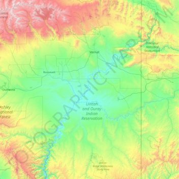
Name: Uintah County topographic map, elevation, terrain.
Location: Uintah County, Utah, United States (39.46171 -110.04785 40.85840 -109.04789)
Average elevation: 6,742 ft
Minimum elevation: 4,573 ft
Maximum elevation: 13,445 ft
Uintah County lies on the east side of Utah. Its eastern border abuts the western border of the state of Colorado. The Green River flows southwestward through the central part of the county, and forms the lower part of Uintah County's border with Duchesne County. Two miles south of Ouray, Utah, it is joined by the Duchesne River (flowing east-southeastward from Duchesne County), and three miles (5 km) farther down by the White River (flowing west-northwestward from Colorado). Ten miles farther downstream it is joined by Willow Creek, flowing northward from the lower part of the county. The county terrain slopes to the south and to the west, with its highest parts found on the crests of the Uinta Mountains, running east-west across the north border. The maximum elevation along those crests is around 12,276' (3742m). The county has a total area of 4,501 square miles (11,660 km2), of which 4,480 square miles (11,600 km2) is land and 22 square miles (57 km2) (0.5%) is water.
Other topographic maps
Click on a map to view its topography, its elevation and its terrain.
Salt Lake City
United States > Utah > Salt Lake County
Salt Lake City, Salt Lake County, Utah, United States
Average elevation: 5,223 ft
Provo
United States > Utah > Utah County
Provo, Utah County, Utah, United States
Average elevation: 5,669 ft
Bryce Canyon National Park
United States > Utah > Garfield County
Bryce Canyon National Park, Garfield County, Utah, United States
Average elevation: 7,411 ft
Saint George
United States > Utah > Washington County
Saint George, Washington County, Utah, United States
Average elevation: 3,048 ft
Zion National Park
United States > Utah > Washington County
Zion National Park, Washington County, Utah, United States
Average elevation: 6,158 ft
Lehi
United States > Utah > Utah County
Lehi, Utah County, Utah, 84043, United States
Average elevation: 4,806 ft
Park City
United States > Utah > Summit County
Park City, Summit County, Utah, United States
Average elevation: 7,513 ft
Orem
United States > Utah > Utah County
Orem, Utah County, Utah, United States
Average elevation: 4,783 ft
Moab
United States > Utah > Grand County
Moab, Grand County, Utah, 84532, United States
Average elevation: 4,452 ft
North Ogden
United States > Utah > Weber County
North Ogden, Weber County, Utah, 84414, United States
Average elevation: 4,803 ft
Bountiful
United States > Utah > Davis County
Bountiful, Davis County, Utah, 84010, United States
Average elevation: 4,846 ft
Sandy
United States > Utah > Salt Lake County
Sandy, Salt Lake County, Utah, United States
Average elevation: 4,514 ft
Logan
United States > Utah > Cache County
Logan, Cache County, Utah, United States
Average elevation: 4,915 ft
Eagle Mountain
United States > Utah > Utah County
Eagle Mountain, Utah County, Utah, 84005, United States
Average elevation: 5,213 ft
West Jordan
United States > Utah > Salt Lake County
West Jordan, Salt Lake County, Utah, United States
Average elevation: 4,501 ft
Herriman
United States > Utah > Salt Lake County
Herriman, Salt Lake County, Utah, United States
Average elevation: 5,390 ft
Grand Staircase–Escalante National Monument
Grand Staircase–Escalante National Monument, Utah, 84017, United States
Average elevation: 6,093 ft
Cedar City
United States > Utah > Iron County
Cedar City, Iron County, Utah, United States
Average elevation: 6,480 ft
Ephraim
United States > Utah > Sanpete County
Ephraim, Sanpete County, Utah, 84627, United States
Average elevation: 5,577 ft
Lake Powell
United States > Utah > San Juan County
Lake Powell, San Juan County, Utah, United States
Average elevation: 5,102 ft
Canyonlands National Park
United States > Utah > Wayne County
Canyonlands National Park, Wayne County, Utah, United States
Average elevation: 5,312 ft
Layton
United States > Utah > Davis County
Layton, Davis County, Utah, United States
Average elevation: 4,505 ft
Heber City
United States > Utah > Wasatch County > Heber > Heber City
Heber City, Heber, Wasatch County, Utah, 84032, United States
Average elevation: 5,771 ft
La Verkin
United States > Utah > Washington County
La Verkin, Washington County, Utah, United States
Average elevation: 3,665 ft
South Jordan
United States > Utah > Salt Lake County
South Jordan, Salt Lake County, Utah, 84095, United States
Average elevation: 4,616 ft
Boulder
United States > Utah > Garfield County
Boulder, Garfield County, Utah, 84716, United States
Average elevation: 6,939 ft
Kings Peak
United States > Utah > Duchesne County
Kings Peak, Duchesne County, Utah, United States
Average elevation: 12,280 ft
Mirror Lake
United States > Utah > Beaver County
Mirror Lake, Beaver County, Utah, United States
Average elevation: 9,895 ft
Richfield
United States > Utah > Sevier County
Richfield, Sevier County, Utah, 84701, United States
Average elevation: 5,443 ft
Freemont Springs Park
United States > Utah > Utah County > Eagle Mountain
Freemont Springs Park, Eagle Mountain, Utah County, Utah, United States
Average elevation: 4,888 ft
Cottonwood Heights
United States > Utah > Salt Lake County
Cottonwood Heights, Salt Lake County, Utah, United States
Average elevation: 4,823 ft
Bender Mountain
United States > Utah > Daggett County
Bender Mountain, Daggett County, Utah, United States
Average elevation: 8,278 ft
Veyo
United States > Utah > Washington County
Veyo, Washington County, Utah, 84782, United States
Average elevation: 4,524 ft
Price Canyon Recreation Area
United States > Utah > Carbon County
Price Canyon Recreation Area, Carbon County, Utah, United States
Average elevation: 7,418 ft
Kimball Junction
United States > Utah > Summit County > Kimball Junction
Kimball Junction, Summit County, Utah, 84098, United States
Average elevation: 6,575 ft
Buckeye Lake
United States > Utah > Summit County
Buckeye Lake, Summit County, Utah, United States
Average elevation: 9,764 ft
Butterfly Lake
United States > Utah > Garfield County
Butterfly Lake, Garfield County, Utah, United States
Average elevation: 9,724 ft
Ogden
United States > Utah > Weber County
Ogden, Weber County, Utah, United States
Average elevation: 4,915 ft
Randolph
United States > Utah > Rich County
Randolph, Rich County, Utah, United States
Average elevation: 6,289 ft
Washington County
Washington County, Utah, United States
Average elevation: 5,085 ft
Greenville
United States > Utah > Cache County > North Logan
Greenville, North Logan, Cache County, Utah, 84341, United States
Average elevation: 4,557 ft
Sullivan Knoll
United States > Utah > Washington County > Hurricane
Sullivan Knoll, Hurricane, Washington County, Utah, 84737, United States
Average elevation: 3,415 ft
Cove Fort
United States > Utah > Millard County
Cove Fort, Millard County, Utah, United States
Average elevation: 6,102 ft
Joes Valley Dam
United States > Utah > Emery County
Joes Valley Dam, Emery County, Utah, United States
Average elevation: 7,369 ft
Bear Lake
United States > Utah > Rich County > Garden City
Bear Lake, Garden City, Rich County, Utah, United States
Average elevation: 6,686 ft
Lilly Lake
United States > Utah > Summit County
Lilly Lake, Summit County, Utah, United States
Average elevation: 10,033 ft
Wallace Heights
United States > Utah > Salt Lake County > Sandy
Wallace Heights, Sandy, Salt Lake County, Utah, 84070, United States
Average elevation: 4,416 ft
Mount Brigham
United States > Utah > Piute County
Mount Brigham, Piute County, Utah, United States
Average elevation: 10,787 ft
Brian Head
United States > Utah > Iron County
Brian Head, Iron County, Utah, 84719, United States
Average elevation: 9,944 ft
Greenville
United States > Utah > Beaver County
Greenville, Beaver County, Utah, 84731, United States
Average elevation: 5,705 ft