
Make a donation
Gear up for your next adventure:
As an Amazon Associate, this site earns from qualifying purchases at no extra cost to you.
Merrimack River topographic map
Click on the map to display elevation.
Make a donation
Gear up for your next adventure:
As an Amazon Associate, this site earns from qualifying purchases at no extra cost to you.
About this map
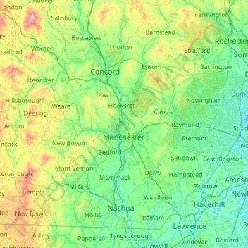
Name: Merrimack River topographic map, elevation, terrain.
Location: Merrimack River, New Hampshire, United States (42.63739 -71.65720 43.43659 -70.80297)
Average elevation: 515 ft
Minimum elevation: -16 ft
Maximum elevation: 2,887 ft
New Hampshire trails, hiking, mountain biking, running and outdoor activities
Make a donation
Gear up for your next adventure:
As an Amazon Associate, this site earns from qualifying purchases at no extra cost to you.
Other topographic maps
Click on a map to view its topography, its elevation and its terrain.
New Durham Corner
United States > New Hampshire > Strafford County > New Durham
Average elevation: 604 ft
Make a donation
Gear up for your next adventure:
As an Amazon Associate, this site earns from qualifying purchases at no extra cost to you.
Mount Washington
United States > New Hampshire > Coos County
Mount Washington, also known as Agiocochook, is an ultra-prominent mountain in the state of New Hampshire. It is the highest peak in the Northeastern United States at 6,288.2 ft (1,916.6 m) and the most topographically prominent mountain east of the Mississippi River.
Average elevation: 5,144 ft
Kezer Seminary
United States > New Hampshire > Merrimack County > Canterbury
Average elevation: 633 ft
Mount Washington
United States > New Hampshire > Coos County
Mount Washington, in New Hampshire, is the highest peak in the Northeastern United States at 6,288.2 ft (1,916.6 m) and the most topographically prominent mountain east of the Mississippi River.
Average elevation: 5,144 ft
Make a donation
Gear up for your next adventure:
As an Amazon Associate, this site earns from qualifying purchases at no extra cost to you.
Make a donation
Gear up for your next adventure:
As an Amazon Associate, this site earns from qualifying purchases at no extra cost to you.
Make a donation
Gear up for your next adventure:
As an Amazon Associate, this site earns from qualifying purchases at no extra cost to you.
Stone Pond
United States > New Hampshire > Cheshire County > Marlow > Gee Mill
Average elevation: 1,411 ft
Streeter Mountain
United States > New Hampshire > Grafton County > Dorchester
Average elevation: 1,473 ft
Mirror Lake
United States > New Hampshire > Carroll County > Tuftonboro > Mirror Lake
Average elevation: 554 ft
Catamount Mountain
United States > New Hampshire > Merrimack County > Pittsfield
Average elevation: 922 ft
Make a donation
Gear up for your next adventure:
As an Amazon Associate, this site earns from qualifying purchases at no extra cost to you.
Make a donation
Gear up for your next adventure:
As an Amazon Associate, this site earns from qualifying purchases at no extra cost to you.
Hampton River
United States > New Hampshire > Rockingham County > Hampton Falls
Average elevation: 3 ft
Make a donation
Gear up for your next adventure:
As an Amazon Associate, this site earns from qualifying purchases at no extra cost to you.
South Beacon Shoal
United States > New Hampshire > Rockingham County > Portsmouth
Average elevation: 13 ft
Nineacre Island
United States > New Hampshire > Carroll County > Moultonborough
Average elevation: 518 ft
Make a donation
Gear up for your next adventure:
As an Amazon Associate, this site earns from qualifying purchases at no extra cost to you.
Cow Island
United States > New Hampshire > Carroll County > Tuftonboro > Fox Point
Average elevation: 531 ft
Make a donation
Gear up for your next adventure:
As an Amazon Associate, this site earns from qualifying purchases at no extra cost to you.
Whortleberry Island
United States > New Hampshire > Carroll County > Tuftonboro > Chase Point
Average elevation: 512 ft
Whortleberry Island
United States > New Hampshire > Carroll County > Tuftonboro > Chase Point
Average elevation: 512 ft
Make a donation
Gear up for your next adventure:
As an Amazon Associate, this site earns from qualifying purchases at no extra cost to you.
Black Cat Island
United States > New Hampshire > Carroll County > Moultonborough
Average elevation: 512 ft
Little Bear Island
United States > New Hampshire > Carroll County > Tuftonboro
Average elevation: 525 ft
Sleepers Island
United States > New Hampshire > Belknap County > Alton > Smith Point
Average elevation: 535 ft
Make a donation
Gear up for your next adventure:
As an Amazon Associate, this site earns from qualifying purchases at no extra cost to you.
Halfmoon Lake
United States > New Hampshire > Belknap County > Barnstead > Fernhill
Average elevation: 699 ft
Make a donation
Gear up for your next adventure:
As an Amazon Associate, this site earns from qualifying purchases at no extra cost to you.
South Charlestown
United States > New Hampshire > Sullivan County > Charlestown
Average elevation: 502 ft
Make a donation
Gear up for your next adventure:
As an Amazon Associate, this site earns from qualifying purchases at no extra cost to you.
New Ipswich Center
United States > New Hampshire > Hillsborough County > New Ipswich
Average elevation: 1,063 ft
Make a donation
Gear up for your next adventure:
As an Amazon Associate, this site earns from qualifying purchases at no extra cost to you.
North Charlestown
United States > New Hampshire > Sullivan County > Charlestown
Average elevation: 531 ft
Make a donation
Gear up for your next adventure:
As an Amazon Associate, this site earns from qualifying purchases at no extra cost to you.
Center Strafford
United States > New Hampshire > Strafford County > Strafford
Average elevation: 486 ft
Winnipesaukee
United States > New Hampshire > Carroll County > Moultonborough
Average elevation: 528 ft
Make a donation
Gear up for your next adventure:
As an Amazon Associate, this site earns from qualifying purchases at no extra cost to you.
Mount Monadnock
United States > New Hampshire > Cheshire County > Jaffrey
From the base to the summit, floral species diminish with increasingly shallow soil levels. The summit is home to many different specialized sub-alpine species which can retain moisture for long periods of time. Alpine and sub-alpine species include mountain ash, cotton grass, sheep laurel, mountain sandwort,…
Average elevation: 2,254 ft
Kolelemook Lake
United States > New Hampshire > Sullivan County > Springfield
Average elevation: 1,519 ft
Make a donation
Gear up for your next adventure:
As an Amazon Associate, this site earns from qualifying purchases at no extra cost to you.
Make a donation
Gear up for your next adventure:
As an Amazon Associate, this site earns from qualifying purchases at no extra cost to you.
Make a donation
Gear up for your next adventure:
As an Amazon Associate, this site earns from qualifying purchases at no extra cost to you.
Make a donation
Gear up for your next adventure:
As an Amazon Associate, this site earns from qualifying purchases at no extra cost to you.
South Uncanoonuc Mountain
United States > New Hampshire > Hillsborough County > Goffstown
Average elevation: 797 ft
Make a donation
Gear up for your next adventure:
As an Amazon Associate, this site earns from qualifying purchases at no extra cost to you.
Mount Washington
United States > New Hampshire > Coos County
Mount Washington is an ultra-prominent mountain in the state of New Hampshire. It is the highest peak in the Northeastern United States at 6,288.2 ft (1,916.6 m) and the most topographically prominent mountain east of the Mississippi River.
Average elevation: 5,144 ft
Souhegan River
United States > New Hampshire > Hillsborough County > Milford > East Milford
Average elevation: 276 ft
Souhegan River Watershed Dam Number 35
United States > New Hampshire > Hillsborough County > New Ipswich > Smithville
Average elevation: 1,145 ft
Make a donation
Gear up for your next adventure:
As an Amazon Associate, this site earns from qualifying purchases at no extra cost to you.
Piscataquog River
United States > New Hampshire > Hillsborough County > Manchester
Average elevation: 194 ft
Make a donation
Gear up for your next adventure:
As an Amazon Associate, this site earns from qualifying purchases at no extra cost to you.
Make a donation
Gear up for your next adventure:
As an Amazon Associate, this site earns from qualifying purchases at no extra cost to you.