Geolocate

Nevada City topographic map

Interactive map

Click on the map to display elevation.

About this map

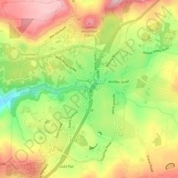
Name: Nevada City topographic map, elevation, terrain.

Location: Nevada City, Nevada County, California, 95959, United States (39.24376 -121.04050 39.27804 -121.00690)

Average elevation: 2,684 ft

Minimum elevation: 2,254 ft

Maximum elevation: 3,097 ft

Nevada County trails, hiking, mountain biking, running and outdoor activities

Other topographic maps

Click on a map to view its topography, its elevation and its terrain.

Soda Springs

United States > California > Nevada County

Average elevation: 6,969 ft

Sebastopol

United States > California > Nevada County > North San Juan

Average elevation: 1,893 ft

Lake Wildwood

United States > California > Nevada County

Average elevation: 1,404 ft

Penn Valley

United States > California > Nevada County > Penn Valley

Average elevation: 1,522 ft

Rough and Ready

United States > California > Nevada County

Average elevation: 1,975 ft

Pinecrest

United States > California > Nevada County

Average elevation: 2,428 ft

Rough and Ready

United States > California > Nevada County

Average elevation: 1,975 ft

Lake of the Pines

United States > California > Nevada County

Lake of the Pines is commonly associated with a gated residential community which surrounds a reservoir, also named Lake of the Pines. The reservoir was created by damming Magnolia Creek, in the Bear River watershed, and it has a maximum elevation of 459 m (1507 ft). The gated community contains a golf course…

Average elevation: 1,581 ft

Relief

United States > California > Nevada County

Average elevation: 3,914 ft

Donner

United States > California > Nevada County > Donner

Average elevation: 7,175 ft

Truckee

United States > California > Nevada County > Truckee

Average elevation: 6,099 ft

Spring Hill

United States > California > Nevada County > Grass Valley

Average elevation: 2,648 ft