
Palo Duro Canyon State Park topographic map
Interactive map
Click on the map to display elevation.
About this map
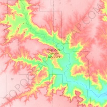
Name: Palo Duro Canyon State Park topographic map, elevation, terrain.
Location: Palo Duro Canyon State Park, Randall County, Texas, USA (34.83813 -101.72079 34.98589 -101.56318)
Average elevation: 3,215 ft
Minimum elevation: 2,595 ft
Maximum elevation: 3,540 ft
Other topographic maps
Click on a map to view its topography, its elevation and its terrain.