
Make a donation
Gear up for your next adventure:
As an Amazon Associate, this site earns from qualifying purchases at no extra cost to you.
Bradford County topographic map
Click on the map to display elevation.
Make a donation
Gear up for your next adventure:
As an Amazon Associate, this site earns from qualifying purchases at no extra cost to you.
About this map
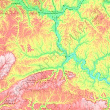
Name: Bradford County topographic map, elevation, terrain.
Location: Bradford County, Pennsylvania, United States (41.54129 -76.92687 42.00203 -76.11517)
Average elevation: 1,430 ft
Minimum elevation: 620 ft
Maximum elevation: 2,444 ft
Pennsylvania trails, hiking, mountain biking, running and outdoor activities
Make a donation
Gear up for your next adventure:
As an Amazon Associate, this site earns from qualifying purchases at no extra cost to you.
Other topographic maps
Click on a map to view its topography, its elevation and its terrain.
East Texas
United States > Pennsylvania > Lehigh County > Lower Macungie Township
Average elevation: 413 ft
Hopeland
United States > Pennsylvania > Lancaster County > Clay Township > Clay
Average elevation: 509 ft
Falls Township Community Park
United States > Pennsylvania > Bucks County > Falls Township > Wheat Sheaf
Average elevation: 30 ft
Make a donation
Gear up for your next adventure:
As an Amazon Associate, this site earns from qualifying purchases at no extra cost to you.
Tanglewood Estate
United States > Pennsylvania > Pike County > Palmyra Township
Average elevation: 1,470 ft
Dingmans Ferry
United States > Pennsylvania > Pike County > Delaware Township
Average elevation: 630 ft
Make a donation
Gear up for your next adventure:
As an Amazon Associate, this site earns from qualifying purchases at no extra cost to you.
Drumore Center
United States > Pennsylvania > Lancaster County > Drumore Township
Average elevation: 574 ft
Chestnut Ridge
United States > Pennsylvania > Westmoreland County > Fairfield Township
Average elevation: 1,529 ft
Shermans Dale
United States > Pennsylvania > Perry County > Carroll Township
Average elevation: 561 ft
Cairnbrook
United States > Pennsylvania > Somerset County > Shade Township
Average elevation: 2,274 ft
Make a donation
Gear up for your next adventure:
As an Amazon Associate, this site earns from qualifying purchases at no extra cost to you.
Ithan
United States > Pennsylvania > Delaware County > Radnor Township > Saint Davids
Average elevation: 381 ft
Cross Fork
United States > Pennsylvania > Potter County > Stewardson Township
Average elevation: 1,532 ft
Make a donation
Gear up for your next adventure:
As an Amazon Associate, this site earns from qualifying purchases at no extra cost to you.
Tannersville
United States > Pennsylvania > Monroe County > Pocono Township
Average elevation: 1,037 ft
Stoufferstown
United States > Pennsylvania > Franklin County > Guilford Township
Average elevation: 682 ft
Saint Peters
United States > Pennsylvania > Chester County > Warwick Township
Average elevation: 515 ft
Make a donation
Gear up for your next adventure:
As an Amazon Associate, this site earns from qualifying purchases at no extra cost to you.
Yellow Creek
United States > Pennsylvania > Bedford County > Hopewell Township > Yellow Creek
Average elevation: 1,060 ft
Millburn
United States > Pennsylvania > Mercer County > Springfield Township
Average elevation: 1,168 ft
Evansburg State Park
United States > Pennsylvania > Montgomery County > Worcester Township > Cedars
Average elevation: 230 ft
Make a donation
Gear up for your next adventure:
As an Amazon Associate, this site earns from qualifying purchases at no extra cost to you.
Baptist Hill
United States > Pennsylvania > Chester County > Tredyffrin Township
Average elevation: 335 ft
North Towanda
United States > Pennsylvania > Bradford County > North Towanda Township
Average elevation: 938 ft
Bonnie Brook
United States > Pennsylvania > Butler County > Summit Township
Average elevation: 1,204 ft
Make a donation
Gear up for your next adventure:
As an Amazon Associate, this site earns from qualifying purchases at no extra cost to you.
Vera Cruz Station
United States > Pennsylvania > Lehigh County > Upper Milford Township
Average elevation: 653 ft
Upper Glasgow
United States > Pennsylvania > Montgomery County > West Pottsgrove Township
Average elevation: 282 ft
Dresher
United States > Pennsylvania > Montgomery County > Upper Dublin Township
Average elevation: 269 ft
Falling Springs Reservoir
United States > Pennsylvania > Lackawanna County > Ransom Township
Average elevation: 1,230 ft
Make a donation
Gear up for your next adventure:
As an Amazon Associate, this site earns from qualifying purchases at no extra cost to you.
Dingmans Ferry
United States > Pennsylvania > Pike County > Delaware Township
Average elevation: 630 ft
Starview
United States > Pennsylvania > York County > East Manchester Township
Average elevation: 509 ft
Make a donation
Gear up for your next adventure:
As an Amazon Associate, this site earns from qualifying purchases at no extra cost to you.
Sagamore Estates
United States > Pennsylvania > Pike County > Shohola Township
Average elevation: 1,352 ft
Illick's Mill Road Gateway
United States > Pennsylvania > Northampton County > Bethlehem
Average elevation: 344 ft
Vance
United States > Pennsylvania > Washington County > South Strabane Township
Average elevation: 1,217 ft
Make a donation
Gear up for your next adventure:
As an Amazon Associate, this site earns from qualifying purchases at no extra cost to you.
Croydon Heights
United States > Pennsylvania > Bucks County > Bristol Township > Croydon
Average elevation: 33 ft
Fitzwatertown
United States > Pennsylvania > Montgomery County > Upper Dublin Township
Average elevation: 282 ft
Exton
United States > Pennsylvania > Chester County > West Whiteland Township
Average elevation: 410 ft
Make a donation
Gear up for your next adventure:
As an Amazon Associate, this site earns from qualifying purchases at no extra cost to you.
Carlisle Springs
United States > Pennsylvania > Cumberland County > Middlesex Township
Average elevation: 597 ft
Glade Mills
United States > Pennsylvania > Butler County > Middlesex Township
Average elevation: 1,178 ft
Donegal Lake
United States > Pennsylvania > Westmoreland County > Donegal Township
Average elevation: 1,617 ft
Make a donation
Gear up for your next adventure:
As an Amazon Associate, this site earns from qualifying purchases at no extra cost to you.
Spring Plains
United States > Pennsylvania > York County > Springettsbury Township
Average elevation: 495 ft
Knickerbocker
United States > Pennsylvania > Chester County > Willistown Township
Average elevation: 417 ft
Make a donation
Gear up for your next adventure:
As an Amazon Associate, this site earns from qualifying purchases at no extra cost to you.
Malden Place
United States > Pennsylvania > Washington County > Centerville
Average elevation: 1,053 ft
Centreville
United States > Pennsylvania > Lehigh County > Lower Macungie Township
Average elevation: 472 ft
Bass Lake
United States > Pennsylvania > York County > Newberry Township > Valley Green
Average elevation: 469 ft
Sturgeon
United States > Pennsylvania > Allegheny County > North Fayette Township
Average elevation: 1,096 ft
Make a donation
Gear up for your next adventure:
As an Amazon Associate, this site earns from qualifying purchases at no extra cost to you.
Bentley Creek
United States > Pennsylvania > Bradford County > Ridgebury Township
Average elevation: 1,368 ft
Freemont
United States > Pennsylvania > Chester County > West Nottingham Township
Average elevation: 377 ft
Make a donation
Gear up for your next adventure:
As an Amazon Associate, this site earns from qualifying purchases at no extra cost to you.
Franklin Pike Corners
United States > Pennsylvania > Crawford County > West Mead Township
Average elevation: 1,237 ft
Port Trevorton
United States > Pennsylvania > Snyder County > Union Township
Average elevation: 528 ft
Woxall
United States > Pennsylvania > Montgomery County > Upper Salford Township
Average elevation: 322 ft
Make a donation
Gear up for your next adventure:
As an Amazon Associate, this site earns from qualifying purchases at no extra cost to you.
Perryville
United States > Pennsylvania > Westmoreland County > Bell Township
Average elevation: 1,198 ft
Hamilton Court
United States > Pennsylvania > Montgomery County > Lower Merion Township > Ardmore
Average elevation: 335 ft
Make a donation
Gear up for your next adventure:
As an Amazon Associate, this site earns from qualifying purchases at no extra cost to you.
Kellettville
United States > Pennsylvania > Forest County > Kingsley Township
Average elevation: 1,447 ft
Middlebury Center
United States > Pennsylvania > Tioga County > Middlebury Township
Average elevation: 1,516 ft
Make a donation
Gear up for your next adventure:
As an Amazon Associate, this site earns from qualifying purchases at no extra cost to you.
Canoe Creek
United States > Pennsylvania > Blair County > Frankstown Township
Average elevation: 1,138 ft
Make a donation
Gear up for your next adventure:
As an Amazon Associate, this site earns from qualifying purchases at no extra cost to you.
Arlingham
United States > Pennsylvania > Montgomery County > Springfield Township
Average elevation: 217 ft
Make a donation
Gear up for your next adventure:
As an Amazon Associate, this site earns from qualifying purchases at no extra cost to you.
Dalmatia
United States > Pennsylvania > Northumberland County > Lower Mahanoy Township
Average elevation: 564 ft
Stoverstown
United States > Pennsylvania > York County > North Codorus Township
Average elevation: 561 ft
Make a donation
Gear up for your next adventure:
As an Amazon Associate, this site earns from qualifying purchases at no extra cost to you.
Springtown
United States > Pennsylvania > Bucks County > Springfield Township
Average elevation: 535 ft
Pleasant View
United States > Pennsylvania > Centre County > Spring Township
Average elevation: 971 ft
Make a donation
Gear up for your next adventure:
As an Amazon Associate, this site earns from qualifying purchases at no extra cost to you.
Blue Mountain
United States > Pennsylvania > Schuylkill County > Washington Township
The ridge of Blue Mountain runs for 150 miles (240 km) through Pennsylvania, reaching an elevation of 2,270 feet (690 m) above sea level just north of the Pennsylvania Turnpike, near the borough of Newburg. Most of the ridgecrest, however, only reaches between 1,400 and 1,700 feet (430 and 520 m) in elevation.…
Average elevation: 741 ft
Hazelton Mills
United States > Pennsylvania > McKean County > Bradford Township
Average elevation: 1,962 ft
Tyler State Park
United States > Pennsylvania > Bucks County > Northampton Township
Average elevation: 220 ft
Make a donation
Gear up for your next adventure:
As an Amazon Associate, this site earns from qualifying purchases at no extra cost to you.
Coolspring
United States > Pennsylvania > Jefferson County > Oliver Township
Average elevation: 1,490 ft
East Waterford
United States > Pennsylvania > Juniata County > Tuscarora Township
Average elevation: 843 ft
Bartram's Garden
United States > Pennsylvania > Philadelphia County > Philadelphia
Average elevation: 43 ft
Make a donation
Gear up for your next adventure:
As an Amazon Associate, this site earns from qualifying purchases at no extra cost to you.
Mauntain View Lake
United States > Pennsylvania > Dauphin County > Halifax Township
Average elevation: 679 ft
Long Pond
United States > Pennsylvania > Monroe County > Tunkhannock Township
Long Pond is named after the wetland topography formed by Tunkhannock Creek. Within the Long Pond community are public access lands, containing many species of plants and animals. Long Pond has been called "the most unique inland freshwater wetland in the state".
Average elevation: 1,873 ft
Make a donation
Gear up for your next adventure:
As an Amazon Associate, this site earns from qualifying purchases at no extra cost to you.