
Sugar Creek topographic map
Interactive map
Click on the map to display elevation.
About this map
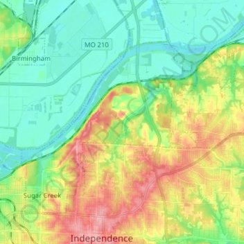
Name: Sugar Creek topographic map, elevation, terrain.
Location: Sugar Creek, Jackson County, Missouri, 64054, United States (39.10221 -94.46073 39.17598 -94.33406)
Average elevation: 827 ft
Minimum elevation: 702 ft
Maximum elevation: 1,053 ft
Jackson County trails, hiking, mountain biking, running and outdoor activities
Other topographic maps
Click on a map to view its topography, its elevation and its terrain.
Lee's Summit
United States > Missouri > Jackson County > Lee's Summit
When the surveyors for the Missouri Pacific Railroad came through, the local people and the railroad wanted to name the town in Dr. Lea's honor. He had a farm on the highest point and near the path of the tracks, and his murder had taken place near the site of the proposed depot. So they chose the name of…
Average elevation: 945 ft
Downtown Kansas City
United States > Missouri > Jackson County > Downtown Kansas City
Average elevation: 889 ft
Grain Valley
United States > Missouri > Jackson County > Grain Valley > Grain Valley
Average elevation: 850 ft
New Santa Fe
United States > Missouri > Jackson County > Kansas City > New Santa Fe
Average elevation: 942 ft