
Make a donation
Gear up for your next adventure:
As an Amazon Associate, this site earns from qualifying purchases at no extra cost to you.
Rockaway Beach topographic map
Click on the map to display elevation.
Make a donation
Gear up for your next adventure:
As an Amazon Associate, this site earns from qualifying purchases at no extra cost to you.
About this map
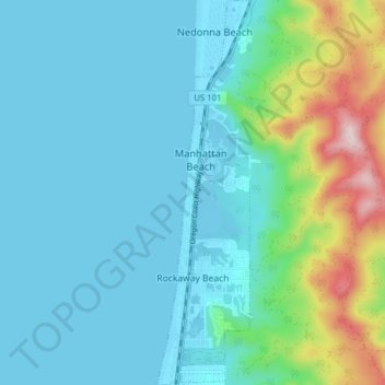
Name: Rockaway Beach topographic map, elevation, terrain.
Average elevation: 249 ft
Minimum elevation: -10 ft
Maximum elevation: 1,385 ft
Tillamook County trails, hiking, mountain biking, running and outdoor activities
Make a donation
Gear up for your next adventure:
As an Amazon Associate, this site earns from qualifying purchases at no extra cost to you.
Other topographic maps
Click on a map to view its topography, its elevation and its terrain.
Neahkahnie Mountain
United States > Oregon > Tillamook County
Neahkahnie Mountain is a mountain, or headland, on the Oregon Coast, north of Manzanita in Oswald West State Park overlooking U.S. Route 101, that has a pass elevation of approximately 620 feet (190 m), which is the third highest point of the highway in Oregon. The peak is part of the Northern Oregon Coast…
Average elevation: 538 ft
Make a donation
Gear up for your next adventure:
As an Amazon Associate, this site earns from qualifying purchases at no extra cost to you.
Make a donation
Gear up for your next adventure:
As an Amazon Associate, this site earns from qualifying purchases at no extra cost to you.