
Truckee topographic map
Interactive map
Click on the map to display elevation.
Truckee
Truckee is characterized by its dramatic topography set in the Sierra Nevada mountain range. The town sits at an elevation of approximately 5,817 feet (1,774 meters), surrounded by a stunning landscape of rugged mountains, rolling hills, and expansive forested areas. Prominent features include Donner Pass, which is a significant historical and geographical landmark, and Donner Lake, a picturesque body of water nestled among the peaks. The terrain is diverse, offering steep slopes and high-altitude trails, which are popular for hiking, biking, and skiing, particularly in winter when the region is blanketed in snow. The unique combination of elevation and natural beauty makes Truckee a prime location for outdoor enthusiasts and those seeking scenic vistas year-round.
About this map
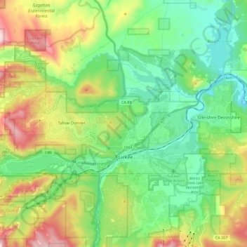
Name: Truckee topographic map, elevation, terrain.
Location: Truckee, Nevada County, California, United States (39.31616 -120.30160 39.38733 -120.07730)
Average elevation: 6,293 ft
Minimum elevation: 5,449 ft
Maximum elevation: 8,136 ft
Nevada County trails, hiking, mountain biking, running and outdoor activities
Other topographic maps
Click on a map to view its topography, its elevation and its terrain.
Lake of the Pines
United States > California > Nevada County
Lake of the Pines is commonly associated with a gated residential community which surrounds a reservoir, also named Lake of the Pines. The reservoir was created by damming Magnolia Creek, in the Bear River watershed, and it has a maximum elevation of 459 m (1507 ft). The gated community contains a golf course…
Average elevation: 1,581 ft
Junction House
United States > California > Nevada County > Junction House
Average elevation: 4,252 ft