
Bear Valley Springs topographic map
Interactive map
Click on the map to display elevation.
Bear Valley Springs
Bear Valley Springs is a guarded-gate community in Kern County, California, United States. Bear Valley Springs is in the Tehachapi Mountains and is part of the greater Tehachapi area. The elevation ranges from 4,121 feet (1,256 m) to 6,934 feet (2,113 m) (Bear Mountain). The population fluctuates between a low during the winter months when snow is common, to a high in the summer months when its elevation keeps it much cooler than surrounding areas and major cities. The population was 5,172 at the 2010 census, up from 4,232 at the 2000 census. For statistical purposes, the United States Census Bureau has defined Bear Valley Springs as a census-designated place (CDP). The census definition of the area may not precisely correspond to local understanding of the area with the same name.
About this map
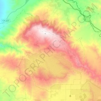
Name: Bear Valley Springs topographic map, elevation, terrain.
Average elevation: 3,950 ft
Minimum elevation: 984 ft
Maximum elevation: 6,919 ft
Kern County trails, hiking, mountain biking, running and outdoor activities
Other topographic maps
Click on a map to view its topography, its elevation and its terrain.
Johannesburg
United States > California > Kern County
Johannesburg is a census-designated place (CDP) in Kern County, California, in a mining district of the Rand Mountains. Johannesburg is located 1 mile (1.6 km) east-northeast of Randsburg, at an elevation of 3,517 feet (1,072 m). The terminus of the Randsburg Railway was here from 1897 to 1933. The population…
Average elevation: 3,619 ft
Maricopa
United States > California > Kern County
Maricopa is a city in Kern County, California. Maricopa is located 6.5 miles (10 km) south-southeast of Taft, at an elevation of 883 feet (269 m). The population was 1,154 at the 2010 census, up from 1,111 at the 2000 census. The Carrizo Plain is located to the northwest, and the enormous Midway-Sunset Oil…
Average elevation: 912 ft
Kernville
United States > California > Kern County > Kernville
Kernville is a census-designated place (CDP) in the southern Sierra Nevada, in Kern County, California, United States. Kernville is located 42 miles (68 km) northeast of Bakersfield, at an elevation of 2,667 feet (813 m). The population was 1,549 at the 2020 United States census, up from 1,395 at the 2010…
Average elevation: 3,724 ft
Weldon
United States > California > Kern County
Weldon is a census-designated place (CDP) in Kern County, California, United States. It sits at the southeast tip of Lake Isabella. Weldon is located 9 miles (14 km) east-southeast of Wofford Heights, at an elevation of 2,654 feet (809 m). The population was 2,642 at the 2010 census, up from 2,387 at the 2000…
Average elevation: 3,379 ft
Bealville
United States > California > Kern County
Bealville is an unincorporated community in Kern County, California. It is located on the Union Pacific Railroad (formerly Southern Pacific Railroad) 1.25 miles (2 km) south of Caliente, at an elevation of 1,811 feet (552 m). The area was named after Edward Fitzgerald Beale, who owned the adjacent Rancho El…
Average elevation: 1,864 ft
Bakersfield
United States > California > Kern County > Bakersfield
Most of Bakersfield’s major streets are six-lane divided roads with bike lanes, with almost every street in the city having proper lane signage for bicycle traffic. Bikes are a popular method of transportation in Bakersfield, due to the city’s relatively flat topography and grid-like street system. Newer…
Average elevation: 528 ft
Fellows
United States > California > Kern County
Fellows is a census-designated place (CDP) in Kern County, California, United States. Fellows is located 5 miles (8 km) west-northwest of Taft, at an elevation of 1,316 feet (401 m). The population was 106 at the 2010 census, down from 153 at the 2000 census. Fellows is surrounded on all sides by the enormous…
Average elevation: 1,378 ft
Lost Hills
United States > California > Kern County
Lost Hills (formerly, Lost Hill) is a census-designated place (CDP) in Kern County, California, United States. Lost Hills is located 42 miles (68 km) west-northwest of Bakersfield, at an elevation of 305 feet (93 m). The population was 2,412 at the 2010 census, up from 1,938 at the 2000 census. About 75% of…
Average elevation: 269 ft
Wofford Heights
United States > California > Kern County
Wofford Heights is a census-designated place (CDP) in the southern Sierra Nevada, in Kern County, California, United States. Wofford Heights is located in the west Kern River Valley, 3.5 miles (5.6 km) south-southwest of Kernville, at an elevation of 2,684 feet (818 m). The population was 2,200 at the 2010…
Average elevation: 3,655 ft
Lebec
United States > California > Kern County
According to the United States Census Bureau, Lebec has an area of 15.3 square miles (40 km2). The community, which is near Tejon Pass, lies at an elevation of 3,481 feet (1,061 m).
Average elevation: 3,812 ft
Bodfish
United States > California > Kern County
Bodfish is located 32 miles (51 km) east-northeast of Bakersfield, at an elevation of 2,687 feet (819 m).
Average elevation: 3,031 ft
Stallion Springs
United States > California > Kern County > Stallion Springs
Average elevation: 3,927 ft
Twin Oaks
United States > California > Kern County
Twin Oaks is an unincorporated community in Kern County, California. It is located 1.5 miles (2.4 km) east-northeast of Loraine, at an elevation of 2,825 feet (861 m).
Average elevation: 3,100 ft
Pine Mountain Club
United States > California > Kern County
Pine Mountain Club has an area of 16.7 square miles (43.25 km2). It ranges from 4,901 to 6,400 feet (1,494 to 1,951 m) in elevation. The community sits in a deep valley of the San Emigdio Mountains, on the San Andreas fault. It is surrounded by Los Padres National Forest. The settlement lies between Apache…
Average elevation: 6,125 ft
Sand Canyon
United States > California > Kern County
Sand Canyon is an unincorporated community in Kern County, California. It is located on Cache Creek 7 miles (11 km) east of Tehachapi, at an elevation of 4,500 feet (1,400 m).
Average elevation: 3,071 ft
Woodford
United States > California > Kern County
Woodford is an unincorporated community in Kern County, California. It is located on the railroad 1 mile (1.6 km) southeast of Keene, at an elevation of 2746 feet (837 m).
Average elevation: 2,949 ft
Edwards Air Force Base
United States > California > Kern County
Ground tests began five days after the first XP-59 arrived on 21 September 1942. First flight took place on 30 September when the XP-59 rose to 10 feet (3.0 m) altitude for 0.5 miles (0.80 km) during taxi testing. However, the first official flight was 1 October 1942 with NACA, Navy Bureau of Aeronautics,…
Average elevation: 2,395 ft