
Green River topographic map
Interactive map
Click on the map to display elevation.
About this map
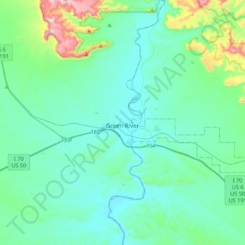
Name: Green River topographic map, elevation, terrain.
Location: Green River, Emery County, Utah, 84525, United States (38.94991 -110.30786 39.04646 -110.00398)
Average elevation: 4,426 ft
Minimum elevation: 4,012 ft
Maximum elevation: 6,719 ft
Other topographic maps
Click on a map to view its topography, its elevation and its terrain.
Orangeville
United States > Utah > Emery County
Orangeville, Emery County, Utah, 84537, United States
Average elevation: 5,827 ft
Castle Dale
United States > Utah > Emery County
Castle Dale, Emery County, Utah, 84513, United States
Average elevation: 5,768 ft
Huntington
United States > Utah > Emery County > Huntington
Huntington, Emery County, Utah, 84528, United States
Average elevation: 5,797 ft
Castle Dale
United States > Utah > Emery County > Castle Dale > Castle Dale
Castle Dale, Emery County, Utah, 84513, United States
Average elevation: 5,725 ft
The Wickiup
United States > Utah > Emery County
The Wickiup, Emery County, Utah, United States
Average elevation: 6,493 ft
Joes Valley Reservoir
United States > Utah > Emery County
Joes Valley Reservoir, Emery County, Utah, United States
Average elevation: 7,487 ft
San Rafel Swell overlook
United States > Utah > Emery County
San Rafel Swell overlook, San Rafael River Road, Emery County, Utah, United States
Average elevation: 4,892 ft