Geolocate

Crestone topographic map

Interactive map

Click on the map to display elevation.

About this map

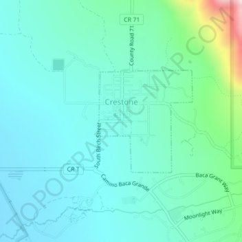
Name: Crestone topographic map, elevation, terrain.

Location: Crestone, Saguache County, Colorado, United States (37.98753 -105.70240 37.99896 -105.68913)

Average elevation: 8,018 ft

Minimum elevation: 7,733 ft

Maximum elevation: 9,324 ft

Saguache County trails, hiking, mountain biking, running and outdoor activities

Other topographic maps

Click on a map to view its topography, its elevation and its terrain.

Liberty

United States > Colorado > Saguache County

Average elevation: 8,573 ft

Bonanza

United States > Colorado > Saguache County

Average elevation: 9,974 ft

Villa Grove

United States > Colorado > Saguache County

Average elevation: 7,989 ft

Continental Divide

United States > Colorado > Saguache County

Average elevation: 11,854 ft

Center

United States > Colorado > Saguache County

Average elevation: 7,648 ft

Sargents

United States > Colorado > Saguache County

Average elevation: 8,780 ft

Poncha Pass

United States > Colorado > Saguache County

Average elevation: 9,016 ft

Sargents Mesa

United States > Colorado > Saguache County

Average elevation: 11,365 ft