Tetons topographic map
Interactive map
Click on the map to display elevation.
About this map
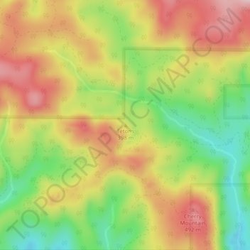
Name: Tetons topographic map, elevation, terrain.
Location: Tetons, Yamhill County, Oregon, United States (45.17284 -123.62655 45.17294 -123.62645)
Average elevation: 1,332 ft
Minimum elevation: 915 ft
Maximum elevation: 1,719 ft
Other topographic maps
Click on a map to view its topography, its elevation and its terrain.
McMinnville
United States > Oregon > Yamhill County
McMinnville, Yamhill County, Oregon, 97128, United States
Average elevation: 164 ft
Newberg
United States > Oregon > Yamhill County
Newberg, Yamhill County, Oregon, United States
Average elevation: 200 ft
Lafayette
United States > Oregon > Yamhill County
Lafayette, Yamhill County, Oregon, 97127, United States
Average elevation: 171 ft
McGuire Reservoir
United States > Oregon > Yamhill County
McGuire Reservoir, Yamhill County, Oregon, United States
Average elevation: 1,909 ft
Bald Peak State Scenic Viewpoint
United States > Oregon > Yamhill County
Bald Peak State Scenic Viewpoint, Southwest Bald Peak Road, Yamhill County, Oregon, United States
Average elevation: 1,096 ft
Carlton
United States > Oregon > Yamhill County
Carlton, Yamhill County, Oregon, 97111, United States
Average elevation: 167 ft
Amity
United States > Oregon > Yamhill County
Amity, Yamhill County, Oregon, United States
Average elevation: 167 ft
Dayton
United States > Oregon > Yamhill County
Dayton, Yamhill County, Oregon, United States
Average elevation: 141 ft
Dundee
United States > Oregon > Yamhill County
Dundee, Yamhill County, Oregon, 97115, United States
Average elevation: 226 ft
Willamina
United States > Oregon > Yamhill County > Willamina
Willamina, Yamhill County, Oregon, United States
Average elevation: 305 ft
Yamhill
United States > Oregon > Yamhill County > Yamhill
Yamhill, Yamhill County, Oregon, United States
Average elevation: 180 ft