Geolocate

Chamblee topographic map

Interactive map

Click on the map to display elevation.

About this map

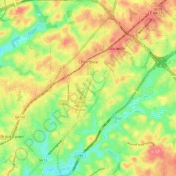
Name: Chamblee topographic map, elevation, terrain.

Location: Chamblee, DeKalb County, Georgia, 30341, United States (33.84057 -84.32248 33.91988 -84.27301)

Average elevation: 974 ft

Minimum elevation: 843 ft

Maximum elevation: 1,106 ft

DeKalb County trails, hiking, mountain biking, running and outdoor activities

Other topographic maps

Click on a map to view its topography, its elevation and its terrain.

Brook Run Park

United States > Georgia > DeKalb County > Dunwoody

Average elevation: 1,001 ft

North Druid Hills

United States > Georgia > DeKalb County

Average elevation: 955 ft

Habersham

United States > Georgia > DeKalb County

Average elevation: 1,001 ft

Candler-McAfee

United States > Georgia > DeKalb County

Average elevation: 945 ft

Windwood

United States > Georgia > DeKalb County > Dunwoody

Average elevation: 1,007 ft

Scottdale

United States > Georgia > DeKalb County

Average elevation: 991 ft

Dunwoody

United States > Georgia > DeKalb County > Dunwoody

Average elevation: 1,014 ft

Belvedere Park

United States > Georgia > DeKalb County

Average elevation: 974 ft

Redan

United States > Georgia > DeKalb County

Average elevation: 928 ft

WSB-FM (Atlanta)

United States > Georgia > DeKalb County > Atlanta

Average elevation: 1,007 ft

Henrico

United States > Georgia > DeKalb County > Henrico

Average elevation: 883 ft