
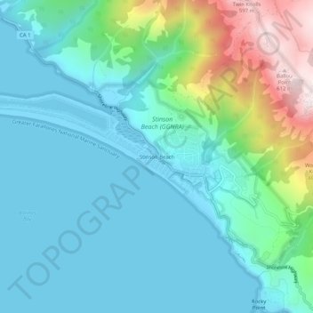
Stinson Beach topographic map
Interactive map
Click on the map to display elevation.
About this map
Name: Stinson Beach topographic map, elevation, terrain.
Average elevation: 436 ft
Minimum elevation: -7 ft
Maximum elevation: 2,067 ft
Marin County trails, hiking, mountain biking, running and outdoor activities
Other topographic maps
Click on a map to view its topography, its elevation and its terrain.
Kentfield
United States > California > Marin County > Kentfield
Kentfield (formerly Ross Landing, Tamalpais, and Kent) is a census-designated place (CDP) in Marin County, California, United States, just north of San Francisco. Kentfield is located 2 miles (3 km) southwest of downtown San Rafael, at an elevation of 115 feet (35 m). The population was 6,808 at the 2020…
Average elevation: 495 ft
Tamalpais-Homestead Valley
United States > California > Marin County > Mill Valley
Average elevation: 302 ft
Fairfax
United States > California > Marin County
Fairfax is an incorporated town in Marin County, California, United States. Fairfax is located 3.25 miles (5.2 km) west-northwest of San Rafael, at an elevation of 115 feet (35 m). The population was 7,605 at the 2020 census.
Average elevation: 318 ft
Corte Madera
United States > California > Marin County
Corte Madera (/ˈkɔːrtə məˈdɛrə/; Spanish for "Chop Wood") is an incorporated town in Marin County, California. Corte Madera is located 3.25 miles (5.2 km) south of San Rafael, at an elevation of 39 feet (12 m). The population was 10,222 at the 2020 census. The town was named after the Spanish…
Average elevation: 171 ft
Cascade Canyon Open Space Preserve
United States > California > Marin County > Fairfax > Manor
Average elevation: 627 ft
Dillon Beach
United States > California > Marin County
Dillon Beach is a census-designated place (CDP) in Marin County, California, United States. It is located 3.25 miles (5.2 km) west of Tomales, at an elevation of 89 ft (27 m). The population was 246 at the 2020 census. Dillon Beach was named after the founder, George Dillon, who settled there in 1858. The area…
Average elevation: 184 ft
Marin Headlands State Park
United States > California > Marin County > Marin City
Average elevation: 223 ft
San Geronimo
United States > California > Marin County
San Geronimo (Spanish: San Gerónimo, meaning "St. Jerome") is a census-designated place (CDP) located in the San Geronimo Valley in Marin County, California in the United States. San Geronimo is located with Lagunitas-Forest Knolls to its west, Woodacre to its east, and 8 miles (13 km) southwest of downtown…
Average elevation: 768 ft