Geolocate

Gear up for your next adventure:

As an Amazon Associate, this site earns from qualifying purchases at no extra cost to you.

👉 Easily get elevation data in JSON, GeoTIFF and KML formats using Elevation API
Thank you for supporting this site ❤️
Make a donation

Yankton County topographic map

Click on the map to display elevation.

Gear up for your next adventure:

As an Amazon Associate, this site earns from qualifying purchases at no extra cost to you.

Gear up for your next adventure:

As an Amazon Associate, this site earns from qualifying purchases at no extra cost to you.

👉 Easily get elevation data in JSON, GeoTIFF and KML formats using Elevation API
Thank you for supporting this site ❤️
Make a donation

About this map

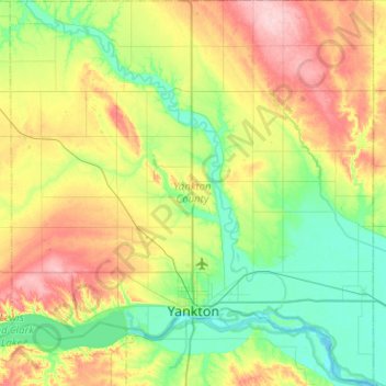
Name: Yankton County topographic map, elevation, terrain.

Location: Yankton County, South Dakota, United States (42.79964 -97.63750 43.16998 -97.16023)

Average elevation: 1,329 ft

Minimum elevation: 1,145 ft

Maximum elevation: 1,683 ft

South Dakota trails, hiking, mountain biking, running and outdoor activities

Gear up for your next adventure:

As an Amazon Associate, this site earns from qualifying purchases at no extra cost to you.

👉 Easily get elevation data in JSON, GeoTIFF and KML formats using Elevation API
Thank you for supporting this site ❤️
Make a donation

Other topographic maps

Click on a map to view its topography, its elevation and its terrain.

Black Hills

United States > South Dakota > Pennington County

The Black Hills is an isolated mountain range rising from the Great Plains of North America in western South Dakota and extending into Wyoming, United States. Black Elk Peak, which rises to 7,242 feet (2,207 m), is the range's highest summit. The name of the range in Lakota is Pahá Sápa. It encompasses the…

Average elevation: 6,214 ft

Mount Rushmore

United States > South Dakota > Pennington County

Mount Rushmore National Memorial is centered on a colossal sculpture carved into the granite face of Mount Rushmore (Lakota: Tȟuŋkášila Šákpe, or Six Grandfathers) in the Black Hills near Keystone, South Dakota. Sculptor Gutzon Borglum created the sculpture's design and oversaw the project's execution…

Average elevation: 5,125 ft

Nemo

United States > South Dakota > Lawrence County

Average elevation: 4,888 ft

Myers Lake

United States > South Dakota > Grant County

Average elevation: 1,909 ft

Gear up for your next adventure:

As an Amazon Associate, this site earns from qualifying purchases at no extra cost to you.

Thank you for supporting this site ❤️
Make a donation

Black Elk Peak

United States > South Dakota > Pennington County

In September 2016, a team of professional surveyors obtained precise GNSS data over the course of two days and found the highest natural rock to be at 7,231.32 feet (2,204.11 m) NAVD88 and a nearby secondary peak located approximately 300 feet south of the lookout tower and unofficially named "McGillicuddy's…

Average elevation: 6,309 ft

Lily

United States > South Dakota > Day County

Average elevation: 1,841 ft

Rockerville

United States > South Dakota > Pennington County

Average elevation: 4,446 ft

Merritt

United States > South Dakota > Lawrence County

Average elevation: 5,253 ft

Gear up for your next adventure:

As an Amazon Associate, this site earns from qualifying purchases at no extra cost to you.

Thank you for supporting this site ❤️
Make a donation

Lake Byron

United States > South Dakota > Beadle County

Average elevation: 1,273 ft

Green Valley

United States > South Dakota > Pennington County

Average elevation: 3,064 ft

Junction City

United States > South Dakota > Union County

Average elevation: 1,204 ft

Junction City

United States > South Dakota > Union County

Average elevation: 1,204 ft

Gear up for your next adventure:

As an Amazon Associate, this site earns from qualifying purchases at no extra cost to you.

Thank you for supporting this site ❤️
Make a donation

Victor

United States > South Dakota > Roberts County

Average elevation: 1,073 ft

Lake Albert

United States > South Dakota > Kingsbury County

Average elevation: 1,670 ft

Lake Byron

United States > South Dakota > Beadle County

Average elevation: 1,273 ft

John Penor Dam

United States > South Dakota > Perkins County

Average elevation: 2,726 ft

Richmond Dam

United States > South Dakota > Brown County

Average elevation: 1,375 ft

Gear up for your next adventure:

As an Amazon Associate, this site earns from qualifying purchases at no extra cost to you.

Thank you for supporting this site ❤️
Make a donation

Beaulieu Dam

United States > South Dakota > Tripp County

Average elevation: 2,146 ft

Nahant

United States > South Dakota > Lawrence County

Average elevation: 5,925 ft

Long Valley

United States > South Dakota > Jackson County

Average elevation: 2,690 ft

Gear up for your next adventure:

As an Amazon Associate, this site earns from qualifying purchases at no extra cost to you.

Thank you for supporting this site ❤️
Make a donation

Manchester

United States > South Dakota > Kingsbury County

Average elevation: 1,532 ft

Silver City

United States > South Dakota > Pennington County

Average elevation: 5,036 ft

Berne

United States > South Dakota > Custer County

Average elevation: 5,902 ft

Sage Creek

United States > South Dakota > Pennington County

Average elevation: 2,838 ft

Gear up for your next adventure:

As an Amazon Associate, this site earns from qualifying purchases at no extra cost to you.

Thank you for supporting this site ❤️
Make a donation

Moon

United States > South Dakota > Pennington County

Average elevation: 6,358 ft

Rapid Creek

United States > South Dakota > Pennington County

Average elevation: 5,541 ft

Gear up for your next adventure:

As an Amazon Associate, this site earns from qualifying purchases at no extra cost to you.

Thank you for supporting this site ❤️
Make a donation

Spokane

United States > South Dakota > Custer County

Average elevation: 4,573 ft

Swett

United States > South Dakota > Bennett County

Average elevation: 3,376 ft

Lakota Lake

United States > South Dakota > Custer County

Average elevation: 4,623 ft

State Game Lodge

United States > South Dakota > Custer County

Average elevation: 4,423 ft

Gear up for your next adventure:

As an Amazon Associate, this site earns from qualifying purchases at no extra cost to you.

Thank you for supporting this site ❤️
Make a donation

Terry Peak

United States > South Dakota > Lawrence County

Average elevation: 6,365 ft

Maitland

United States > South Dakota > Maitland

Average elevation: 5,213 ft

Watertown

United States > South Dakota > Codington County > Watertown

According to the United States Census Bureau, the city has a total area of 25.04 square miles (64.85 km2), of which 17.45 square miles (45.20 km2) is land and 7.59 square miles (19.66 km2) is water. Watertown sits on the Big Sioux River and two major lakes, Pelican Lake and Lake Kampeska. Most of Watertown…

Average elevation: 1,804 ft

Sisseton

United States > South Dakota > Roberts County > Sisseton

Average elevation: 1,250 ft

Gear up for your next adventure:

As an Amazon Associate, this site earns from qualifying purchases at no extra cost to you.

Thank you for supporting this site ❤️
Make a donation

Spearfish

United States > South Dakota > Lawrence County > Spearfish

Average elevation: 4,236 ft

John Penor Dam

United States > South Dakota > Perkins County

Average elevation: 2,667 ft

Olsonville

United States > South Dakota > Todd County > Olsonville

Average elevation: 2,805 ft

Bourne Slough

United States > South Dakota > Lake County > Chautauqua

Average elevation: 1,627 ft