
Querétaro topographic map
Interactive map
Click on the map to display elevation.
Querétaro
Three of Mexico’s geographic zones cover parts of the state. The Mesa del Centro is in the center-west of the state, and mostly consists of small mesas with an average altitude of 2,000 meters (6,562 feet) above sea level (ASL). A few elevations reach over 3,000 meters (9,843 feet). The Sierra Madre Oriental occupies the northeast of the state and includes the cities of Huasteca area. The topography of this area is rugged, with long mountain chains and narrow valleys. Elevations here range between 900 m (2,953 ft) and 3,000 m (9,843 ft) m ASL. The Trans-Mexican Volcanic Belt occupies about half of the state in the center and south. The area is mostly volcanic rock with peaks and mesas between 200 m (656 ft) and 3,000 m (9,843 ft) and valleys between 1,800 m (5,906 ft) and 1,900 m (6,234 ft) ASL.
About this map
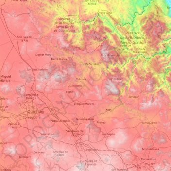
Name: Querétaro topographic map, elevation, terrain.
Location: Querétaro, Mexico (20.01502 -100.59654 21.67001 -99.04308)
Average elevation: 6,522 ft
Minimum elevation: 1,788 ft
Maximum elevation: 10,689 ft
Other topographic maps
Click on a map to view its topography, its elevation and its terrain.
Monterrey
Mexico > Nuevo León > Monterrey
The city of Monterrey is 540 metres (1,770 ft) above sea level in the northeastern state of Nuevo León. Monterrey translated literally from Spanish to English is "King Mount" or "King Mountain", and folk etymology claims that this refers to the city's topography and the large mountains that surround it…
Average elevation: 2,470 ft
Laguna de Santo Tomás
Mexico > Baja California > Municipio de Ensenada > La Bocana
Average elevation: 131 ft
Guadalajara
Mexico > Jalisco > Guadalajara
Under the Köppen climate classification, Guadalajara has a humid subtropical climate (Cwa), a temperate climate that is quite close to a tropical climate, featuring dry warm winters and wet, mildly hot summers. Guadalajara's climate is influenced by its high altitude and the general seasonality of…
Average elevation: 5,157 ft
Tijuana
Mexico > Baja California > Municipio de Tijuana
Housing development in the Tijuana Hills has led to eradication of many seasonal mountain streams. This lack of natural drainage makes places within the city vulnerable to landslides during the rainy season. The varied terrain of Tijuana gives the city elevation extremes that range from sea level to 790 meters…
Average elevation: 463 ft
Matehuala
Mexico > San Luis Potosi > Matehuala
Matehuala is a city in the Mexican state of San Luis Potosí, situated at an elevation of about 1,500 m. Matehuala is also the municipal seat of the municipality of the same name, located in the northern part of the state, on the border with the southwestern corner of Nuevo León. The municipality of Matehuala…
Average elevation: 5,755 ft
Ojo de Agua
Mexico > State of Mexico > Tecámac
Ojo de Agua is the largest colonia in the municipality of Tecámac in State of Mexico, Mexico. It is located in the northeastern part of the state, northeast of Mexico City and within the Greater Mexico City urban area. It had a population of 386,290 people in the 2020 census. Ojo de Agua is the largest…
Average elevation: 7,536 ft
Ciudad Juárez
Due to its location in the Chihuahuan Desert and high altitude, Ciudad Juárez has a cold desert climate (Köppen: BWk). Seasons are distinct, with hot summers, mild springs and autumns, and cold winters. Summer average high is 35 °C (95 °F) with lows of 21 °C (70 °F). Winter highs average 14 °C (57 °F)…
Average elevation: 4,029 ft
Tepic
Located in the central part of the state, it stands at an altitude of 915 metres (3,002 ft) above sea level, on the banks of the Río Mololoa and the Río Tepic, approximately 225 kilometres (140 mi) north-west of Guadalajara, Jalisco. Nearby are the volcanoes of San Juan, Las Navajas, and Sangangüey. Tepic…
Average elevation: 3,022 ft
Iztaccíhuatl
Mexico > Puebla > San Salvador el Verde
The name "Iztaccíhuatl" is Nahuatl for "White (like salt) woman", reflecting the four individual snow-capped peaks which depict the head, chest, knees and feet of a sleeping female when seen from east or west. Iztaccíhuatl is to the north of its twin Popocatépetl, to which it is connected by the high…
Average elevation: 15,525 ft
Popocatépetl
Mexico > State of Mexico > Atlautla
According to paleomagnetic studies, the volcano is about 730,000 years old. It is cone shaped with a diameter of 25 km (16 mi) at its base, with a peak elevation of 5,450 m (17,880 ft). The crater is elliptical with an orientation northeast-southwest. The walls of the crater vary from 600 to 840 m (1,970 to…
Average elevation: 15,781 ft
Toluca
Mexico > State of Mexico > Toluca
Toluca is located at 2600 meters above sea level, being the highest capital city in Mexico and North America, which makes it temperate throughout the year with average temperatures ranging between 6 and 25 degrees Celsius during spring and summer, and from −5 to 20 degrees Celsius in winter. Its climate is…
Average elevation: 8,953 ft
La Paz
Mexico > Baja California Sur > Municipio de La Paz
La Paz is located on the Baja California peninsula on the Bay of La Paz, 210 kilometres (130 mi) south of Ciudad Constitución, municipality of Comondú, and 202 kilometres (126 mi) north of Cabo San Lucas, municipality of Los Cabos. It is located 81 kilometres (50 mi) north of the town of Todos Santos. Its…
Average elevation: 374 ft
Santiago Tulantepec
Mexico > Hidalgo > Santiago Tulantepec de Lugo Guerrero
Average elevation: 7,415 ft
cuerpos de agua las cepas
Mexico > State of Mexico > Almoloya de Alquisiras > Progreso los Hernández (Colonia los Hernández)
Average elevation: 6,388 ft
Guanajuato City
Mexico > Guanajuato > Municipio de Guanajuato
Although only one out of every 100 bodies interred in the cemetery became naturally mummified, the concentration of this phenomenon has led to theories about how they have come about. Some believe that they are the result of people who had been buried alive, after mistakenly declared dead. These people,…
Average elevation: 7,159 ft
Villa de El Carmen Tequexquitla
Mexico > Tlaxcala > El Carmen Tequexquitla
Average elevation: 7,808 ft
Tijuana
Mexico > Baja California > Municipio de Tijuana
Housing development in the Tijuana Hills has led to eradication of many seasonal mountain streams. This lack of natural drainage makes places within the city vulnerable to landslides during the rainy season. The varied terrain of Tijuana gives the city elevation extremes that range from sea level to 790 meters…
Average elevation: 463 ft
Zapopan
Most of the municipality is flat with another quarter having rolling hills. Altitude varies from 1,500 to 2,000 metres (4,900 to 6,600 ft) above sea level. The main elevations are in the Sierra de la Primavera and include Nejahuete, Tajo and El Chapulin. Superficial water flows mostly in arroyos east to the…
Average elevation: 5,243 ft
Iztaccíhuatl
Mexico > Puebla > San Salvador el Verde
The name "Iztaccíhuatl" is Nahuatl for "White (like salt) woman", reflecting the four individual snow-capped peaks which depict the head, chest, knees and feet of a sleeping female when seen from east or west. Iztaccíhuatl is to the north of its twin Popocatépetl, to which it is connected by the high…
Average elevation: 15,525 ft
Tonalá
The municipality is located in the eastern part of the state. With an average altitude of 1.500 meters above sea level, the territory has three kinds of relief: areas of rugged terrain, semi flat and flat areas. The main elevations are the Cerro Cúpula de la Reina, and Xólotl, both 1,720 meters above sea level.
Average elevation: 5,075 ft