
Mercer County topographic map
Interactive map
Click on the map to display elevation.
Mercer County
The county is generally flat and low-lying on the inner coastal plain, which extends up to the Route 1 corridor. Further northwest, terrain rises as it ascends the Piedmont Plateau, with The Sourlands encompassing the far northwestern portion of the county. Baldpate Mountain, in the western part of Hopewell Township, is the highest point in the county, at 480 feet (150 m) above sea level. The lowest elevation is sea level, spread out along the shores of the tidal portions of the Delaware River, Crosswicks Creek and the smaller waterways within the Trenton-Hamilton Marsh in Hamilton Township and the city of Trenton.
About this map
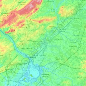
Name: Mercer County topographic map, elevation, terrain.
Location: Mercer County, New Jersey, United States (40.13684 -74.94291 40.42423 -74.48120)
Average elevation: 141 ft
Minimum elevation: 0 ft
Maximum elevation: 577 ft
New Jersey trails, hiking, mountain biking, running and outdoor activities
Other topographic maps
Click on a map to view its topography, its elevation and its terrain.
Sparta
United States > New Jersey > Sussex County > Sparta Township > Sparta
Average elevation: 906 ft
Mount Tammany
United States > New Jersey > Warren County > Knowlton Township
Hiking on Mount Tammany consists of two trails: the red dot trail and the blue dot trail. The red dot trail is 1.2 miles and the blue dot trail is 1.8 miles. Combining the two for one of NJ's most popular hikes is a 3 mile loop. There is a 1201 feet elevation change going up and down the mountain. Generally,…
Average elevation: 876 ft
Springtown
United States > New Jersey > Morris County > Washington Township > Long Valley
Average elevation: 886 ft
Indian Mills
United States > New Jersey > Burlington County > Shamong Township
Average elevation: 82 ft
Danville Mountain
United States > New Jersey > Warren County > Liberty Township
Average elevation: 761 ft
Navesink
United States > New Jersey > Monmouth County > Middletown Township > Navesink
Average elevation: 89 ft
Lake Neepaulin
United States > New Jersey > Sussex County > Wantage
Lake Neepaulin is a man-made lake created from the damming of Neepaulakating Creek, a small mountain stream that was not named until 2002. The creek's headwaters are located approximately 0.4 miles (0.64 km) northwest of the north end of Lake Neepaulin. These headwaters are located a short distance south of…
Average elevation: 564 ft
New Market
United States > New Jersey > Middlesex County > Piscataway Township
Average elevation: 75 ft
Sommers Boy Scout Park
United States > New Jersey > Monmouth County > Oceanport > Sands Point
Average elevation: 7 ft
Mystic Islands
United States > New Jersey > Ocean County > Little Egg Harbor Township
Average elevation: 3 ft
North Middletown
United States > New Jersey > Monmouth County > Middletown Township
Average elevation: 13 ft
Rosedale Park
United States > New Jersey > Mercer County > Hopewell Township
Average elevation: 184 ft
Mickleton
United States > New Jersey > Gloucester County > East Greenwich Township
Average elevation: 59 ft
Petersburg
United States > New Jersey > Warren County > Independence Township
Average elevation: 791 ft
High Point
United States > New Jersey > Sussex County > Montague Township
High Point is a mountain peak within High Point State Park on the border of Wantage Township and Montague Township, Sussex County, New Jersey. Located in the portion of the state known as the Skylands, it is the highest elevation in the state, with a peak elevation of 1,803 feet (550 m). The closest city is…
Average elevation: 1,362 ft
Woodland Lake
United States > New Jersey > Morris County > Pequannock Township
Average elevation: 200 ft
Coxs Corner
United States > New Jersey > Burlington County > Mount Laurel Township
Average elevation: 69 ft
Eagle Rock Reservation
United States > New Jersey > Essex County > West Orange
Average elevation: 472 ft
Cranberry Hill
United States > New Jersey > Ocean County > Lacey Township > Forked River
Average elevation: 33 ft
Franklinville
United States > New Jersey > Gloucester County > Franklin Township
Average elevation: 105 ft
Second Watchung Mountain
United States > New Jersey > Somerset County > Bridgewater Township
Average elevation: 361 ft
North Stelton
United States > New Jersey > Middlesex County > Piscataway Township
Average elevation: 95 ft
Stone Tavern
United States > New Jersey > Monmouth County > Upper Freehold Township
Average elevation: 203 ft
Quakertown
United States > New Jersey > Hunterdon County > Franklin Township
Average elevation: 571 ft
Oak Ridge Dam
United States > New Jersey > Morris County > Jefferson Township
Average elevation: 873 ft
Mantua Creek
United States > New Jersey > Gloucester County > West Deptford Township
Average elevation: 43 ft
Shore View
United States > New Jersey > Middlesex County > Woodbridge Township > Colonia
Average elevation: 95 ft
Linvale
United States > New Jersey > Hunterdon County > East Amwell Township
Average elevation: 358 ft