
Chengdu topographic map
Interactive map
Click on the map to display elevation.
Chengdu
The vast plain on which Chengdu is located has an elevation ranging from 450 to 720 meters (1,480 to 2,360 feet).
About this map
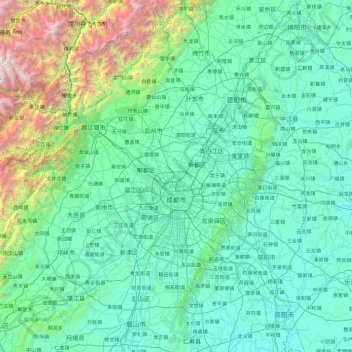
Name: Chengdu topographic map, elevation, terrain.
Location: Chengdu, Sichuan, China (30.09155 102.98962 31.43710 104.89485)
Average elevation: 2,995 ft
Minimum elevation: 1,083 ft
Maximum elevation: 17,464 ft
Other topographic maps
Click on a map to view its topography, its elevation and its terrain.
Mount Gongga
China > Sichuan > Luding County
Mount Gongga (simplified Chinese: 贡嘎山; traditional Chinese: 貢嘎山; pinyin: Gònggá Shān), also known as Minya Konka (Khams Tibetan: མི་ཉག་གངས་དཀར་རི་བོ་, Khams Tibetan pinyin: Mi'nyâg Gong'ga Riwo) and colloquially as "The King of Sichuan Mountains", is the…
Average elevation: 21,312 ft
Xichang
China > Sichuan > Xichang City > Beicheng Subdistrict
Owing to its low latitude and high elevation, Xichang has a monsoon-influenced humid subtropical climate (Köppen Cwa) milder and far sunnier than the Sichuan Basin, with mild, very sunny and dry winters, and very warm, rainy summers. The monthly 24-hour average temperature ranges from 9.9 °C (49.8 °F) in…
Average elevation: 6,463 ft
Mount Genyen
The Ge'nyen Massif (simplified Chinese: 格聂峰; traditional Chinese: 格聶峰; pinyin: Géniè Fēng), is a mountain in the Shaluli Mountains of western Sichuan province, China. With an elevation of 6,204 metres (20,354 ft), it is the third highest peak in the province. It was first climbed in 1988 by a Japanese team.
Average elevation: 17,720 ft
Large High Altitude Air Shower Observatory
China > Sichuan > Daocheng County
The Large High Altitude Air Shower Observatory (LHAASO) is a gamma-ray and cosmic-ray observatory in Daocheng, in the Garzê Tibetan Autonomous Prefecture in Sichuan, China. It is designed to observe air showers triggered by gamma rays and cosmic rays. The observatory is at an altitude of 4,410 metres (14,470…
Average elevation: 14,505 ft
Jiuzhaigou
China > Sichuan > Jiuzhaigou County
The county consists of nine villages in a valley in Sichuan Province. The main ethnic group in the county is Han, with the second being Tibetan. The county seat has an altitude of about 1,400 m (4,600 ft).[1] It has a total area of 2,041 square miles (5,286 km2).[2] As of 2015, the county's total population…
Average elevation: 8,268 ft
Barkam
Due to its elevation, Barkam lies in the transition between a subtropical highland climate (Köppen Cwb) and humid continental climate (Köppen Dwb), with strong monsoonal influences; winters are frosty and summers warm with frequent rain. The monthly 24-hour average temperature ranges from −0.5 °C (31.1…
Average elevation: 12,244 ft
Bazhong
China > Sichuan > Bazhong > Jiangbei Subdistrict
Bazhong is located at the southern end of the Daba Mountains, and borders Shaanxi province to the north, Dazhou to the east, Nanchong to the south, and Guangyuan to the west. Its area is 12,301 square kilometres (4,749 sq mi), which is mountainous with elevations up to 208.3 to 2,507 metres (683 to 8,225 ft)…
Average elevation: 1,883 ft
Litang
China > Sichuan > Litang County
Litang County is located in the west of Sichuan, the southwest of Garze Tibetan Autonomous Prefecture, between the Jinsha River and the Yalong River on the southeastern edge of the Qinghai-Tibet Plateau. The Shaluli Mountains runs from north to south. The terrain is dominated by hill-shaped plateaus and…
Average elevation: 14,124 ft
Garzê Tibetan Autonomous Prefecture
China > Sichuan > Garzê Tibetan Autonomous Prefecture
Average elevation: 12,792 ft
Garze
China > Sichuan > Garzê County
Due to its elevation, Garzê County has a monsoon-influenced humid continental climate (Köppen Dwb) and subarctic climate, with cold but very dry winters, and warm summers with frequent rain. The monthly 24-hour average temperature ranges from −3.9 °C (25.0 °F) in January to 14.2 °C (57.6 °F) in July,…
Average elevation: 13,688 ft