
Garden Valley topographic map
Interactive map
Click on the map to display elevation.
About this map
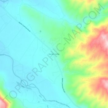
Name: Garden Valley topographic map, elevation, terrain.
Location: Garden Valley, Boise County, Idaho, 83622, United States (44.06989 -115.97206 44.10989 -115.93206)
Average elevation: 3,294 ft
Minimum elevation: 3,018 ft
Maximum elevation: 4,127 ft
Other topographic maps
Click on a map to view its topography, its elevation and its terrain.
Placerville
United States > Idaho > Boise County
Placerville, Boise County, Idaho, 83666, United States
Average elevation: 4,406 ft
Hawley Mountain
United States > Idaho > Boise County
Hawley Mountain, Boise County, Idaho, United States
Average elevation: 6,637 ft
Idaho City
United States > Idaho > Boise County
Idaho City, Boise County, Idaho, 83631, United States
Average elevation: 4,055 ft
Horseshoe Bend
United States > Idaho > Boise County
Horseshoe Bend, Boise County, Idaho, United States
Average elevation: 2,844 ft
North Raker
United States > Idaho > Boise County
North Raker, Boise County, Idaho, United States
Average elevation: 8,698 ft