
Alborz Province topographic map
Interactive map
Click on the map to display elevation.
About this map
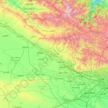
Name: Alborz Province topographic map, elevation, terrain.
Location: Alborz Province, Iran (35.52715 50.16315 36.35089 51.52528)
Average elevation: 5,761 ft
Minimum elevation: 1,857 ft
Maximum elevation: 15,715 ft
Other topographic maps
Click on a map to view its topography, its elevation and its terrain.
Gerik
Iran > West Azerbaijan Province > Maku County > دهستان چایباسارشمالی
Average elevation: 4,633 ft
Ziba Shahr
Iran > Sistan and Baluchestan Province > Konarak County > دهستان جهلیان
Average elevation: 10 ft
Chelleh Khaneh-ye Olya
Iran > East Azerbaijan Province > Shabestar County > دهستان چله خانه
Average elevation: 4,639 ft
Pishin
Iran > Sistan and Baluchestan Province
Pishin has an altitude of 219 metres (721 feet). It is near the Pakistani border, across which is the town of Mand to the east. The Iranian government has set up a customs post to develop border trade between Iran and Pakistan.
Average elevation: 787 ft
Amlash
Iran > Gilan Province > Amlash County > دهستان املش شمالی
Amlash (Persian: املش) is a city in the Central District of Amlash County, Gilan province, in northwestern Iran, serving as the capital of both the county and the district. Amlash sits at an altitude of 13 metres (45 feet).
Average elevation: 217 ft
Kahnuj
Iran > Kerman Province > Kahnuj County > دهستان نخلستان
The elevation of Kahnuj is 5.5 meters above sea level. The Beshagard Mountains, a section of the Zagros Mountains that extend towards Jazmourian and divide Kahnuj from Hormozgan Province, are situated in this county's mountainous region. In general, Kahnuj has a hot climate. Although precipitation is rare, it…
Average elevation: 1,706 ft
ملارد
Iran > Markazi Province > Zarandieh County > Khoshkrud Rural District (Markazi Province)
Average elevation: 4,472 ft
شهرک گاز
Iran > Hormozgan Province > Bandar-e-Abbas County > Bandar Abbas > شهرک گاز
Average elevation: 118 ft
Nasirabad
Iran > Lorestan Province > Khorramabad County > دهستان کاکاشرف > Cham Bagh
Average elevation: 5,013 ft
Tasuj
Iran > East Azerbaijan Province > Shabestar County > دهستان گونی غربی
Average elevation: 4,587 ft
Ali Kandi
Iran > West Azerbaijan Province > Urumia County > دهستان نازلوی جنوبی
Average elevation: 4,298 ft
Hasan Abad
Iran > Isfahan Province > Khansar County > دهستان گلسار
Golpayegan (Persian: گلپایگان)) is a city in the Central District of Golpayegan County, Isfahan province, Iran, serving as capital of both the county and the district. The city is 186 kilometres (116 mi) northwest of Isfahan and 102 kilometres (63 mi) southeast of Arak, at an altitude of 1,830 m. Its…
Average elevation: 7,014 ft
Paskuh
Iran > Sistan and Baluchestan Province > Sib and Suran County > دهستان پسکوه
Average elevation: 4,140 ft
Muteh
Iran > Isfahan Province > Shahin Shahr and Meymeh County > Zarkan RD
Average elevation: 6,302 ft
Gazan-e Bala
Iran > Kurdistan Province > Sanandaj County > دهستان حسین آبادجنوبی
Average elevation: 6,332 ft
Huri
Iran > East Azerbaijan Province > Ajab Shir County > دهستان دیزجرودشرقی
Average elevation: 6,053 ft
Dizaj-e Tavil
Iran > West Azerbaijan Province > Showt County > دهستان یولاگلدی
Average elevation: 3,238 ft
Tochal
Iran > Shemiranat County > دهستان رودبار قصران
Tochal (Persian: توچال Točāl), is a mountain and ski resort located on the Alborz mountain range, adjacent to the metropolitan area of Tehran in northern Iran. It includes a 12-kilometre-long (7.5 mi) ridge. Its highest peak, also called Tochal, is at an elevation of 3,963 metres (13,002 ft) above sea level.
Average elevation: 11,686 ft
park laleh
Iran > Razavi Khorasan > Chenaran County > شهر چناران > Chenaran
Average elevation: 3,842 ft
Malooraan
Iran > Sistan and Baluchestan Province > Nikshahr County > دهستان چاهان
Average elevation: 1,519 ft
Baran
Iran > Khuzestan Province > Izeh County > دهستان سوسن غربی > دوپوک انصاری
Average elevation: 2,887 ft