
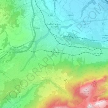
La Roche-sur-Foron topographic map
Interactive map
Click on the map to display elevation.
About this map
Name: La Roche-sur-Foron topographic map, elevation, terrain.
Average elevation: 2,717 ft
Minimum elevation: 1,430 ft
Maximum elevation: 6,106 ft
Other topographic maps
Click on a map to view its topography, its elevation and its terrain.
les Plans
France > Auvergne-Rhône-Alpes > Upper Savoy > Chamonix-Mont-Blanc
Average elevation: 4,646 ft
Le Blanc Chat
France > Auvergne-Rhône-Alpes > Upper Savoy > Épagny Metz-Tessy
Average elevation: 1,598 ft
Les Bossons
France > Auvergne-Rhône-Alpes > Upper Savoy > Chamonix-Mont-Blanc
Average elevation: 4,514 ft
Plan Montmin
France > Auvergne-Rhône-Alpes > Upper Savoy > Talloires-Montmin
Average elevation: 3,543 ft
Les Champs
France > Auvergne-Rhône-Alpes > Upper Savoy > Saint-Jean-d'Aulps
Average elevation: 3,917 ft
La Vendanche
France > Auvergne-Rhône-Alpes > Upper Savoy > Le Grand-Bornand
Average elevation: 4,596 ft
Tré-le-Champ - le Haut
France > Auvergne-Rhône-Alpes > Upper Savoy > Chamonix-Mont-Blanc
Average elevation: 5,699 ft
Le Chesnet
France > Auvergne-Rhône-Alpes > Upper Savoy > La Roche-sur-Foron
Average elevation: 3,885 ft
Mont Gerbet
France > Auvergne-Rhône-Alpes > Upper Savoy > Duingt > Mont Gerbet
Average elevation: 1,752 ft
Chamonix-Mont-Blanc
France > Auvergne-Rhône-Alpes > Upper Savoy > Chamonix-Mont-Blanc > Chamonix-Mont-Blanc
Average elevation: 5,863 ft
Aiguille du Midi
France > Auvergne-Rhône-Alpes > Upper Savoy > Chamonix-Mont-Blanc
Average elevation: 10,161 ft
Refuge de L'Envers des Aiguilles
France > Auvergne-Rhône-Alpes > Upper Savoy > Chamonix-Mont-Blanc
Average elevation: 8,356 ft
Aiguille Verte
France > Auvergne-Rhône-Alpes > Upper Savoy > Chamonix-Mont-Blanc
Average elevation: 10,577 ft
Saint-Jeoire
France > Auvergne-Rhône-Alpes > Upper Savoy > Saint-Jeoire > Saint-Jeoire
Average elevation: 2,723 ft
Argentière
France > Auvergne-Rhône-Alpes > Upper Savoy > Chamonix-Mont-Blanc > Argentière
Average elevation: 5,492 ft