
Compton topographic map
Interactive map
Click on the map to display elevation.
About this map
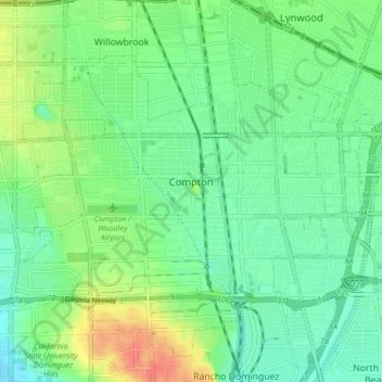
Name: Compton topographic map, elevation, terrain.
Location: Compton, Los Angeles County, California, United States (33.86305 -118.26366 33.92320 -118.17995)
Average elevation: 89 ft
Minimum elevation: 26 ft
Maximum elevation: 210 ft
Los Angeles County trails, hiking, mountain biking, running and outdoor activities
Other topographic maps
Click on a map to view its topography, its elevation and its terrain.
South Los Angeles
United States > California > Los Angeles County > Los Angeles
Average elevation: 1,381 ft
Mount Baden-Powell
United States > California > Los Angeles County
At 9,407 feet (2,867 m) in elevation, Mount Baden-Powell is traditionally considered to be the 5th highest peak of the San Gabriel Range; however it is the second highest peak in the range with more than 1,000 feet (300 m) of prominence, and is the highest peak not part of the Mount San Antonio massif.
Average elevation: 7,969 ft
Point Dume
United States > California > Los Angeles County > Malibu
Offshore, the nutrient-rich and frigid waters of the Pacific enhance the entire marine food web, from primary producers such as algae and zooplankton to apex predators like sand sharks, bottlenose dolphins, and gray whales. Within the Marine Protected Areas (MPAs), the diverse seafloor topography encompasses…
Average elevation: 39 ft
Calabasas Highlands
United States > California > Los Angeles County > Calabasas
Average elevation: 1,325 ft
Hungry Valley SVRA
United States > California > Los Angeles County > Gorman
Average elevation: 4,275 ft
Mount San Antonio
United States > California > Los Angeles County
The prehistoric Hog Back landslide lies in the canyon of San Antonio Creek at 4000' elevation. When the slide occurred, it dammed the river, whose depth built up until the water was released catastrophically, forming a slot canyon which now holds some of the area's few good rock climbing routes (difficulty…
Average elevation: 8,776 ft
Santa Monica Mountains
United States > California > Los Angeles County
On January 17, 2007, an unusually cold storm brought snow in the Santa Monica Mountains. The hills above Malibu picked up three inches (eight centimeters) of snow - the first measurable snow in fifty years. Snow was reported on Boney Peak in the winter of 2005; and in March 2006, snow also fell on the summit…
Average elevation: 659 ft
Horsethief Canyon Park
United States > California > Los Angeles County > San Dimas
Average elevation: 1,224 ft
Malibu Vista
United States > California > Los Angeles County > Unincorporated Santa Monica Mountains
Average elevation: 928 ft
Santa Susana Mountains
United States > California > Los Angeles County > Unincorporated Chatsworth
Average elevation: 1,791 ft
Lake Elizabeth
United States > California > Los Angeles County
The lake, at 3,228 ft (984 m) in elevation, is within the Angeles National Forest. It is a natural perennial lake, but may dry up entirely during drought years. It is south of the western Antelope Valley.
Average elevation: 3,494 ft
Eaton Canyon Waterfall
United States > California > Los Angeles County > Pasadena
Average elevation: 2,096 ft
Twin Lakes
United States > California > Los Angeles County > Unincorporated Chatsworth
Average elevation: 1,312 ft
San Fernando Valley
United States > California > Los Angeles County > Los Angeles
Average elevation: 1,627 ft
El Escorpion Park
United States > California > Los Angeles County > Los Angeles
Average elevation: 1,119 ft
Veterans Administration
United States > California > Los Angeles County > Veterans Administration
Average elevation: 344 ft
Calabasas Highlands
United States > California > Los Angeles County > Calabasas
Average elevation: 1,325 ft
West Puente Valley
United States > California > Los Angeles County > West Puente Valley
Average elevation: 331 ft
West Puente Valley
United States > California > Los Angeles County > West Puente Valley
Average elevation: 331 ft
Monte Nido
United States > California > Los Angeles County > Unincorporated Santa Monica Mountains
Average elevation: 1,073 ft
Johnny Carson Park
United States > California > Los Angeles County > Burbank
Average elevation: 591 ft
San Pedro Hill
United States > California > Los Angeles County > Rancho Palos Verdes
Average elevation: 935 ft
Exposition Park
United States > California > Los Angeles County > Los Angeles
Average elevation: 180 ft
Briggs Terrace
United States > California > Los Angeles County > Briggs Terrace
Average elevation: 2,628 ft
Sierra Madre
United States > California > Los Angeles County > Sierra Madre > Sierra Madre
In 1908, the first Mt. Wilson Trail Race was run. This annual race was discontinued during WWII and reestablished in 1966. The 102nd anniversary of the first running of the Mount Wilson Trail Race and the 44th annual race was run in May 2010. Because of rain, mudslides, falling trees, soil erosion and…
Average elevation: 1,243 ft
Agua Dulce
United States > California > Los Angeles County
Agua Dulce (pronunciation) (Spanish for "Sweet Water") is a census-designated place in Los Angeles County, California, United States. It lies at an elevation of 2,526 feet (770 m), northeast of Santa Clarita. The community had a population of 3,342 at the 2010 census and covers a geographic area of about 23…
Average elevation: 2,635 ft
Malibu Junction
United States > California > Los Angeles County > Agoura Hills
Average elevation: 1,050 ft
Rio de Los Angeles State Park State Recreational Area
United States > California > Los Angeles County > Los Angeles
Average elevation: 463 ft
Rancho Santa Clarita
United States > California > Los Angeles County > Santa Clarita > Rancho Santa Clarita
Average elevation: 1,302 ft