
Alsace topographic map
Interactive map
Click on the map to display elevation.
Alsace
Alsace has a semi-continental climate at low altitude and a continental climate at high altitude. There is fairly low precipitation because the Vosges protect it from the west. The city of Colmar has a sunny microclimate; it is the second driest city in France, with an annual precipitation of 600 mm, making it ideal for vin d'Alsace (Alsatian wine).
About this map
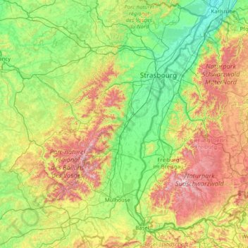
Name: Alsace topographic map, elevation, terrain.
Location: Alsace, Metropolitan France, France (47.42034 6.84132 49.07779 8.23285)
Average elevation: 1,358 ft
Minimum elevation: 328 ft
Maximum elevation: 4,826 ft
Other topographic maps
Click on a map to view its topography, its elevation and its terrain.
Paris
Paris in its early history had only the rivers Seine and Bièvre for water. From 1809, the Canal de l'Ourcq provided Paris with water from less-polluted rivers to the north-east of the capital. From 1857, the civil engineer Eugène Belgrand, under Napoleon III, oversaw the construction of a series of new…
Average elevation: 246 ft
Château du Planchat
France > Nouvelle-Aquitaine > Dordogne > Montignac-Lascaux
Average elevation: 518 ft
La Gravette
France > Provence-Alpes-Côte d'Azur > Alpes-de-Haute-Provence > Barcelonnette
Average elevation: 4,206 ft
Jardins de la Rainville
France > Centre-Val de Loire > Eure-et-Loir > Châteaudun
Average elevation: 430 ft
Sauveterre
France > Occitania > Lozère > Gorges du Tarn Causses > Sainte-Enimie
Average elevation: 3,271 ft
Plage du Canon
France > Provence-Alpes-Côte d'Azur > Var > Saint-Mandrier-sur-Mer
Average elevation: 59 ft
Pièce de Givry
France > Centre-Val de Loire > Indre-et-Loire > Athée-sur-Cher
Average elevation: 302 ft
Mollard Durand
France > Auvergne-Rhône-Alpes > Savoy > Saint-Martin-de-la-Porte
Average elevation: 3,445 ft
Etang des Lames
France > Bourgogne – Franche-Comté > Yonne > Island > La Courcelle
Average elevation: 922 ft
Col de Nice
France > Provence-Alpes-Côte d'Azur > Maritime Alps > L'Escarène
Average elevation: 1,463 ft
La Vieille-Ville
France > Pays de la Loire > Loire-Atlantique > La Chapelle-Glain
Average elevation: 236 ft
Serre Chevalier
France > Provence-Alpes-Côte d'Azur > Hautes-Alpes > Puy-Saint-André
The maximum elevation for skiing is at Telesiege Yret at 2,800 m (9,190 ft) above sea level, and the minimum is 1,200 m (3,940 ft), a total vertical drop of 1,600 m (5,250 ft). One of the outstanding features of Serre Chevalier is the wooded nature of the slopes. The timber line is at 2,150 m (7,050 ft),…
Average elevation: 7,402 ft
Cime de la Bonette
France > Provence-Alpes-Côte d'Azur > Maritime Alps > Saint-Dalmas-le-Selvage
Average elevation: 8,241 ft
La Grande Ragotière
France > Pays de la Loire > Loire-Atlantique > La Regrippière
Average elevation: 262 ft
Mont Agel
France > Provence-Alpes-Côte d'Azur > Maritime Alps > Peille
Mont Agel is a mountain in the Maritime Alps on the border between France and Monaco. The summit of this mount, at 1,148 metres (3,766 ft) above sea level, is on the French side, but the highest point of Monaco, lying on a pathway named Chemin des Révoires, is on its slopes, at an altitude of 161 metres (528…
Average elevation: 2,592 ft
Étang des Vosges
France > Auvergne-Rhône-Alpes > Ain > Saint-Germain-sur-Renon > La Maison Neuve
Average elevation: 899 ft
Bayonne
France > New Aquitaine > Pyrénées-Atlantiques > Bayonne > Bayonne
In the late Quaternary, the current topographic physiognomy was formed—i.e. a set of hills overlooking a swampy lowland. The promontory of Bassussarry–Marracq ultimately extended to the Labourdin foothills. The Grand Bayonne hill is an example. Similarly, on the right bank of the Nive, the heights of…
Average elevation: 75 ft
Danton
France > Auvergne-Rhône-Alpes > Ardèche > Saint-Sauveur-de-Montagut
Average elevation: 1,588 ft
Le Moulin Géant
France > Pays de la Loire > Maine-et-Loire > Rochefort-sur-Loire
Average elevation: 151 ft
L'Égronnière
France > Pays de la Loire > Vendée > Montaigu-Vendée > Saint-Hilaire-de-Loulay
Average elevation: 138 ft
Mont Auxois
France > Bourgogne-Franche-Comté > Côte-d'Or > Alise-Sainte-Reine
Average elevation: 1,007 ft
Bois Grillots
France > Ile-de-France > Seine-et-Marne > Moret-Loing-et-Orvanne
Average elevation: 259 ft