
Susanville topographic map
Interactive map
Click on the map to display elevation.
Susanville
Susanville (formerly known as Rooptown) is a town in and is the county seat of Lassen County, California, United States. Susanville is located on the Susan River in the southern part of the county, at an elevation of 4,186 feet (1,276 m). Its population is 16,728 as of the 2020 census, down from 17,947 from the 2010 census. The Susanville urban area contains 8,995 people and 4,233 households.
About this map
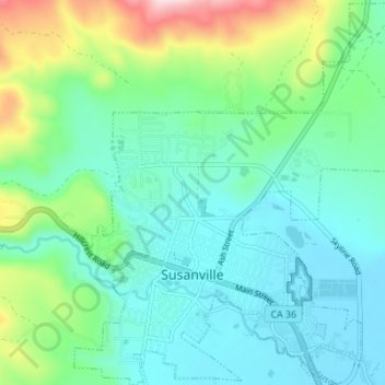
Name: Susanville topographic map, elevation, terrain.
Location: Susanville, Lassen County, California, United States (40.40125 -120.67414 40.45356 -120.60664)
Average elevation: 4,413 ft
Minimum elevation: 4,140 ft
Maximum elevation: 5,285 ft
Lassen County trails, hiking, mountain biking, running and outdoor activities
Other topographic maps
Click on a map to view its topography, its elevation and its terrain.
Westwood
United States > California > Lassen County
Westwood is a census-designated place (CDP) in Lassen County, California, United States. Westwood is located 20 miles (32 km) west-southwest of Susanville, at an elevation of 5,128 feet (1,563 m). Its population is 1,541 as of the 2020 census, down from 1,647 from the 2010 census..
Average elevation: 5,112 ft
Fredonyer Pass
United States > California > Lassen County
Fredonyer Pass, elevation 5,751 feet (1,753 m), is a high mountain pass in Lassen County, California, southwest of Susanville and southeast of Mount Lassen. It lies on the Great Basin Divide between the Feather River to the west and the Susan River and Honey Lake to the east.
Average elevation: 5,738 ft
Herlong
United States > California > Lassen County
Herlong is a census-designated place in Lassen County, California. Herlong is located at the extreme eastern edge of the Sierra Nevada Mountain Range in the southeastern region of Honey Lake Valley, 8 miles (13 km) north of Doyle, at an elevation of 4,114 feet (1,254 m). Its population is 237 as of the 2020…
Average elevation: 4,101 ft