
Make a donation
Gear up for your next adventure:
As an Amazon Associate, this site earns from qualifying purchases at no extra cost to you.
Los Angeles topographic map
Click on the map to display elevation.
Make a donation
Gear up for your next adventure:
As an Amazon Associate, this site earns from qualifying purchases at no extra cost to you.
Los Angeles
Los Angeles is characterized by a diverse and dynamic topography. The city is predominantly situated in a basin bordered by mountain ranges, including the Santa Monica Mountains to the north and the San Gabriel Mountains to the east, with elevations reaching up to about 10,000 feet (3,048 meters) in certain areas. This geographical setup results in varying elevations across the city, with an average elevation of approximately 472 feet (144 meters). The terrain features rolling hills, valleys, and coastal plains that gently slope towards the Pacific Ocean. Notable geographical features include the Los Angeles River, which flows through the city, and various canyons that add to the region's rugged charm. This blend of hills and flatlands creates a unique urban landscape, offering both scenic vistas and opportunities for outdoor recreation.
Make a donation
Gear up for your next adventure:
As an Amazon Associate, this site earns from qualifying purchases at no extra cost to you.
About this map
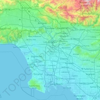
Name: Los Angeles topographic map, elevation, terrain.
Location: Los Angeles, Los Angeles County, California, United States (33.65954 -118.66818 34.33731 -118.15530)
Average elevation: 791 ft
Minimum elevation: -7 ft
Maximum elevation: 7,966 ft
Los Angeles County trails, hiking, mountain biking, running and outdoor activities
Make a donation
Gear up for your next adventure:
As an Amazon Associate, this site earns from qualifying purchases at no extra cost to you.
Other topographic maps
Click on a map to view its topography, its elevation and its terrain.
Will Rogers State Historic Park
United States > California > Los Angeles County > Los Angeles
Average elevation: 499 ft
Hollywood Riviera
United States > California > Los Angeles County > Torrance
Average elevation: 164 ft
Make a donation
Gear up for your next adventure:
As an Amazon Associate, this site earns from qualifying purchases at no extra cost to you.
Oak Spring Canyon Park
United States > California > Los Angeles County > Santa Clarita
Average elevation: 1,703 ft
Make a donation
Gear up for your next adventure:
As an Amazon Associate, this site earns from qualifying purchases at no extra cost to you.
Point Dume
United States > California > Los Angeles County > Malibu
Offshore, the nutrient-rich and frigid waters of the Pacific enhance the entire marine food web, from primary producers such as algae and zooplankton to apex predators like sand sharks, bottlenose dolphins, and gray whales. Within the Marine Protected Areas (MPAs), the diverse seafloor topography encompasses…
Average elevation: 39 ft
Make a donation
Gear up for your next adventure:
As an Amazon Associate, this site earns from qualifying purchases at no extra cost to you.
Mount San Antonio
United States > California > Los Angeles County
The prehistoric Hog Back landslide lies in the canyon of San Antonio Creek at 4000' elevation. When the slide occurred, it dammed the river, whose depth built up until the water was released catastrophically, forming a slot canyon which now holds some of the area's few good rock climbing routes (difficulty…
Average elevation: 8,776 ft
Make a donation
Gear up for your next adventure:
As an Amazon Associate, this site earns from qualifying purchases at no extra cost to you.
Oak Hill
United States > California > Los Angeles County > Unincorporated Santa Monica Mountains
Average elevation: 1,568 ft
Green Valley
United States > California > Los Angeles County
Green Valley is an unincorporated community and census-designated place (CDP) in the Sierra Pelona Mountains, in Los Angeles County, California. It lies at an elevation of 2936 feet (895 m). The population was 1,036 at the 2020 census, up from 1,027 at the 2010 census.
Average elevation: 3,468 ft
Make a donation
Gear up for your next adventure:
As an Amazon Associate, this site earns from qualifying purchases at no extra cost to you.
Altacanyada
United States > California > Los Angeles County > La Cañada Flintridge
Average elevation: 1,916 ft
Twin Lakes
United States > California > Los Angeles County > Unincorporated Chatsworth
Average elevation: 1,312 ft
Portuguese Bend
United States > California > Los Angeles County > Rancho Palos Verdes
Average elevation: 217 ft
San Fernando Valley
United States > California > Los Angeles County > Los Angeles
Average elevation: 1,627 ft
Make a donation
Gear up for your next adventure:
As an Amazon Associate, this site earns from qualifying purchases at no extra cost to you.
Point Dume
United States > California > Los Angeles County > Malibu
Offshore, the nutrient-rich and frigid waters of the Pacific enhance the entire marine food web, from primary producers such as algae and zooplankton to apex predators like sand sharks, bottlenose dolphins, and gray whales. Within the Marine Protected Areas (MPAs), the diverse seafloor topography encompasses…
Average elevation: 39 ft
South Los Angeles
United States > California > Los Angeles County > Los Angeles
Average elevation: 1,381 ft
Make a donation
Gear up for your next adventure:
As an Amazon Associate, this site earns from qualifying purchases at no extra cost to you.
Foxfield Park
United States > California > Los Angeles County > Westlake Village
Average elevation: 988 ft
Make a donation
Gear up for your next adventure:
As an Amazon Associate, this site earns from qualifying purchases at no extra cost to you.
Universal City Overlook
United States > California > Los Angeles County > Los Angeles
Average elevation: 912 ft
San Fernando Valley
United States > California > Los Angeles County > Los Angeles
Average elevation: 1,627 ft
Mount Baden-Powell
United States > California > Los Angeles County
At 9,407 feet (2,867 m) in elevation, Mount Baden-Powell is traditionally considered to be the 5th highest peak of the San Gabriel Range; however it is the second highest peak in the range with more than 1,000 feet (300 m) of prominence, and is the highest peak not part of the Mount San Antonio massif.
Average elevation: 7,969 ft
Make a donation
Gear up for your next adventure:
As an Amazon Associate, this site earns from qualifying purchases at no extra cost to you.
Make a donation
Gear up for your next adventure:
As an Amazon Associate, this site earns from qualifying purchases at no extra cost to you.
Calabasas Highlands
United States > California > Los Angeles County > Calabasas
Average elevation: 1,325 ft
Santa Monica Mountains
United States > California > Los Angeles County
On January 17, 2007, an unusually cold storm brought snow in the Santa Monica Mountains. The hills above Malibu picked up three inches (eight centimeters) of snow - the first measurable snow in fifty years. Snow was reported on Boney Peak in the winter of 2005; and in March 2006, snow also fell on the summit…
Average elevation: 659 ft
Make a donation
Gear up for your next adventure:
As an Amazon Associate, this site earns from qualifying purchases at no extra cost to you.
Mount San Antonio
United States > California > Los Angeles County
The prehistoric Hog Back landslide lies in the canyon of San Antonio Creek at 4000' elevation. When the slide occurred, it dammed the river, whose depth built up until the water was released catastrophically, forming a slot canyon which now holds some of the area's few good rock climbing routes (difficulty…
Average elevation: 8,776 ft
Hungry Valley SVRA
United States > California > Los Angeles County > Gorman
Average elevation: 4,275 ft
Make a donation
Gear up for your next adventure:
As an Amazon Associate, this site earns from qualifying purchases at no extra cost to you.
Make a donation
Gear up for your next adventure:
As an Amazon Associate, this site earns from qualifying purchases at no extra cost to you.
Eaton Canyon Waterfall
United States > California > Los Angeles County > Pasadena
Average elevation: 2,096 ft
Lake Elizabeth
United States > California > Los Angeles County
The lake, at 3,228 ft (984 m) in elevation, is within the Angeles National Forest. It is a natural perennial lake, but may dry up entirely during drought years. It is south of the western Antelope Valley.
Average elevation: 3,494 ft
Horsethief Canyon Park
United States > California > Los Angeles County > San Dimas
Average elevation: 1,224 ft
Make a donation
Gear up for your next adventure:
As an Amazon Associate, this site earns from qualifying purchases at no extra cost to you.
Santa Susana Mountains
United States > California > Los Angeles County > Unincorporated Chatsworth
Average elevation: 1,791 ft
Malibu Vista
United States > California > Los Angeles County > Unincorporated Santa Monica Mountains
Average elevation: 928 ft
Make a donation
Gear up for your next adventure:
As an Amazon Associate, this site earns from qualifying purchases at no extra cost to you.
Twin Lakes
United States > California > Los Angeles County > Unincorporated Chatsworth
Average elevation: 1,312 ft
El Escorpion Park
United States > California > Los Angeles County > Los Angeles
Average elevation: 1,119 ft
Make a donation
Gear up for your next adventure:
As an Amazon Associate, this site earns from qualifying purchases at no extra cost to you.
Miraleste
United States > California > Los Angeles County > Rancho Palos Verdes
Average elevation: 659 ft
Make a donation
Gear up for your next adventure:
As an Amazon Associate, this site earns from qualifying purchases at no extra cost to you.
Make a donation
Gear up for your next adventure:
As an Amazon Associate, this site earns from qualifying purchases at no extra cost to you.
Veterans Administration
United States > California > Los Angeles County > Veterans Administration
Average elevation: 344 ft
Calabasas Highlands
United States > California > Los Angeles County > Calabasas
Average elevation: 1,325 ft
Make a donation
Gear up for your next adventure:
As an Amazon Associate, this site earns from qualifying purchases at no extra cost to you.
Make a donation
Gear up for your next adventure:
As an Amazon Associate, this site earns from qualifying purchases at no extra cost to you.
West Puente Valley
United States > California > Los Angeles County > West Puente Valley
Average elevation: 331 ft
Monte Nido
United States > California > Los Angeles County > Unincorporated Santa Monica Mountains
Average elevation: 1,073 ft
West Puente Valley
United States > California > Los Angeles County > West Puente Valley
Average elevation: 331 ft
Make a donation
Gear up for your next adventure:
As an Amazon Associate, this site earns from qualifying purchases at no extra cost to you.
Johnny Carson Park
United States > California > Los Angeles County > Burbank
Average elevation: 591 ft
Make a donation
Gear up for your next adventure:
As an Amazon Associate, this site earns from qualifying purchases at no extra cost to you.
Make a donation
Gear up for your next adventure:
As an Amazon Associate, this site earns from qualifying purchases at no extra cost to you.
Make a donation
Gear up for your next adventure:
As an Amazon Associate, this site earns from qualifying purchases at no extra cost to you.
Exposition Park
United States > California > Los Angeles County > Los Angeles
Average elevation: 180 ft
San Pedro Hill
United States > California > Los Angeles County > Rancho Palos Verdes
Average elevation: 935 ft
Miraleste
United States > California > Los Angeles County > Rancho Palos Verdes
Average elevation: 659 ft
Make a donation
Gear up for your next adventure:
As an Amazon Associate, this site earns from qualifying purchases at no extra cost to you.